What the Castanyada will be like: will we have to wear short sleeves or will it be cold, like the ones of a lifetime? That is what the maps say
The last years have been marked by temperatures above the average

-
CAT -
CAST
BarcelonaUntil a few years ago, the Castanyada had always been associated with the cold. A night that invited you to eat chestnuts or panellets by the fire to warm up from the pre-winter chill. But, for some time now, this is no longer the case. With the climate crisis and global warming, temperatures keep rising, and most of the recent Castanyadas have been warm for the season, with little cold at night and, even, short-sleeved or shirt-sleeve weather during All Saints' Day.
Therefore, the question is clear: will this Castanyada be warm again or will it be cold, like the ones from back in the day? We are coming off the longest and hottest summer in history, and this month of October the rains and downpours have been very significant and torrential due to all this heat accumulated in the sea as well. Below, we break down what the maps indicate regarding temperatures and rain for the Castanyada weekend. A forecast that we will be updating until the date arrives.
The weather forecast for the Castanyada
After the mild spell experienced earlier in the week which left us with an atmosphere too warm for the season, temperatures have been dropping day by day, and we will arrive at the Castanyada weekend with a clearly more autumnal atmosphere and normalized for the time of year, even with some degrees below average. All of this will be the result of the withdrawal of the anticyclone core towards central and northern Europe, which will allow the arrival of a corridor of cold air towards our home coming from the east of the continent.
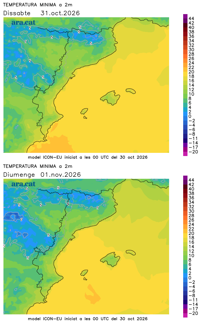
Therefore, this will translate into a cooler atmosphere on Saturday, but especially colder in a generalized way on the night of the Castanyada, fulfilling the meteorological tradition of years past that has been so hard to see lately. So everything suggests that jackets will be essential: it will be pleasant to light the fire to warm up and cook and taste the classic foods of this traditional festival. The minimum temperatures will range between 4 and 9 ºC in a large part of the interior and the pre-coastal area, and will drop below 15 ºC on the coast. Some weak frosts cannot be ruled out in the Pyrenees. During the day, most maximums will range between 16 and 22 ºC on Saturday. On the other hand, on All Saints' Day, the atmosphere will be milder, with many values from 17 to 23 ºC, even higher and warmer in the regions of Catalonia.
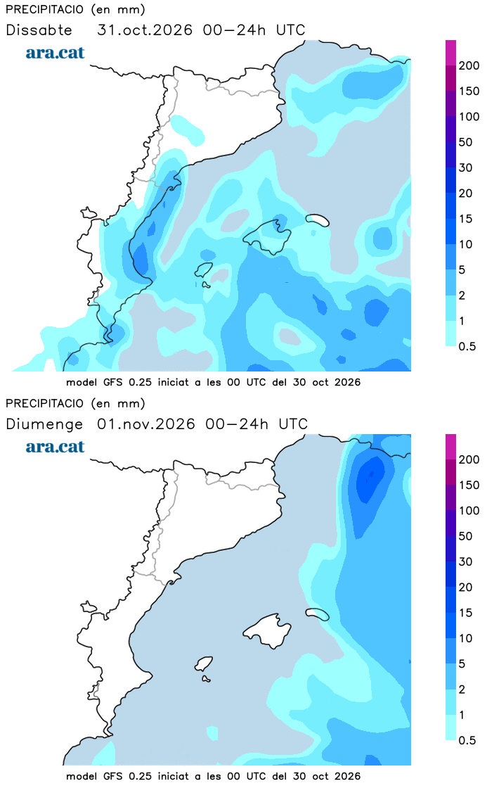
Regarding the state of the sky, the colder wind from the east and northeast will have a maritime path and will be accompanied by humidity, increasing instability on Saturday. It will be a day of variable skies due to the presence of cloud intervals, with radiant sun only on the north face of the Pyrenees. Throughout the day, some scattered showers may fall in the Ebro and Empordà regions, without ruling them out elsewhere. Not much in Catalonia. On the other hand, in the Valencian Community and the Balearic Islands, the showers will be more frequent, and between Valencia and the north of Alicante, the rain may be locally more intense and abundant, as well as in the east of Mallorca.
But will it rain for the Castanyada? The maps indicate that, in general, it will not. In Catalonia, the sky will gradually become clearer at night, with lingering low clouds in the Ebro, while many fogs will appear in the interior. Only some showers will remain at night in the Balearic Islands and in the south of the Valencian Community. On All Saints' Sunday, the situation will improve clearly everywhere and the sun will dominate, with only remains of some weak and local showers between Mallorca and Menorca.
What has the weather been like for the last few Castanyada festivals?
According to the open historical data from Meteocat, recent years have been marked by mostly warm Castanyadas, with values above average and little cold. Obviously, there have been exceptions, but this situation has become even more accentuated during the last decade. The warmest Castanyada recorded recently was that of 2022, with almost 3.5 °C above average across the country, an extraordinary anomaly. That year, the Fabra Observatory in Barcelona –with data since 1914– recorded the warmest Castanyada night in its history, with a minimum of almost 17 °C.
These figures contrast especially when compared with those from the middle of the last century, when even frosts were frequent outside the Pyrenees at this point in autumn. This same observatory recorded its highest maximum temperature on an All Saints' Day since records began last year, reaching up to 23.3 °C.
On the other hand, regarding precipitation, there has been a bit of everything and more variability in recent years. The year 2024 stands out, when we were under the effects of the DANA that caused the tragic and historic rains in Valencia, just two days before the Castanyada. That year, instability remained throughout the long All Saints' Day weekend across the Catalan Countries.
