Sunday with unsettled weather, but with more isolated showers
The storm is subsiding, but it's not completely clearing things up.


BarcelonaThe remnants of the last disturbance are still being felt, and rain has returned, adding new amounts to the more than 200 l/m² already recorded.2 accumulated throughout the entire episode. The last showers on Saturday left between 20 and 40 liters per square meter on the southern coast and pre-coastal areas, although in several cases these figures were exceeded. The interior and pre-coastal areas of the northeast and south of the Ebro River are the areas where the most water accumulated during this entire episode, and in some cases, rainfall exceeded 150 or 200 liters per square meter (you will find all the most relevant updated data at the end of this report). The downpours of these last few days have caused the courses of many Catalan rivers to rise, some of which are saturated with the amount of water that has accumulated in recent months. Some have reached the flood risk threshold, such as the Ter in Sant Joan de les Abadesses (Ripollès), the Ges in Torelló (Osona), the Brugent in Amer (Selva), and the Muga in Sant Llorenç de la Muga (Alt Empordà).
And the weather isn't completely clear. We won't be talking about large accumulations anymore, but there will still be a humid seawater flow towards the ground which, combined with the remnants of the cold air mass aloft, will maintain the marked instability, with more changeable weather and more intermittent showers, especially during the afternoon.
Sunday: the weather won't clear
It will be a very changeable day, with periods of sunshine, but with sudden cloud cover increasing due to the continued instability. Light rain is possible in the morning, especially along the coast and inland areas. In fact, there are currently showers along the Barcelona coast that could eventually affect regions such as Baix Llobregat, Barcelonès, and Camp de Tarragona. Elsewhere, skies will clear, offering a brief respite from the weather. Temperatures will reach a high of 17°C, and the wind will be light from the southeast, with a slight swell along the coast.

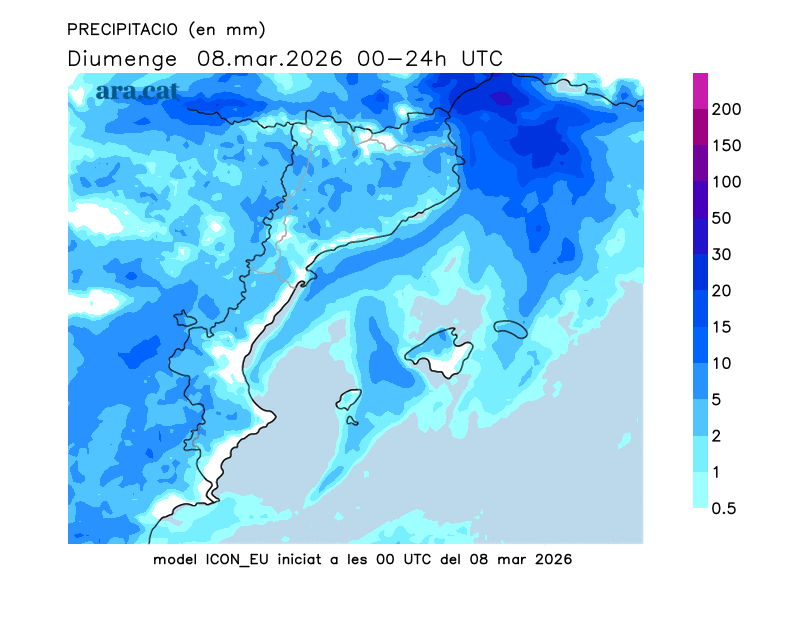
Between midday and nightfall, showers will increase and may appear sporadically anywhere, locally accompanied by thunderstorms. A typical springtime scenario, with the snow level around 1,500 meters.

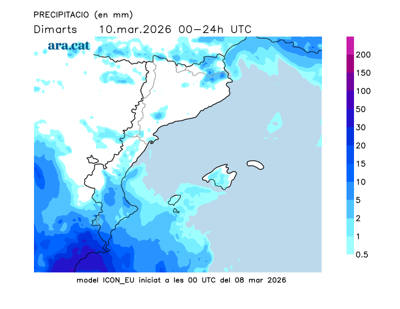
Busy weather next week too
Over the next few days, we will continue to experience the effects of storms and fronts, which will keep the weather unsettled. Monday will start with a calm morning and sunny skies, but the afternoon will become unsettled again, with showers in many areas of the pre-coastal region, the coast, and Central Catalonia. Between Tuesday and Wednesday, the instability will increase, with more showers and some thunderstorms, more likely in the afternoon in the Pyrenees, the Pre-Pyrenees, and the Terres de l'Ebre. The snow level will hover around 1,500 meters. Temperatures will generally remain fairly stable, with a slight drop on Tuesday and Wednesday. From midweek onward, the weather will gradually improve, with more sunny skies becoming more prevalent.
Balance of the leach
The storm that began on Thursday has left very significant rainfall totals. The rains have swept persistently across the entire country, from the coast to the land. Many rainfall totals have ranged between 30 and 60 l/m², although the rain has been less intense in the west, especially in the northern part of the Lleida region. However, in some areas, these figures have been significantly exceeded, as in the northeast interior and the Terres de l'Ebre, where some areas have seen more than 150 or 200 l/m². As for snow accumulation, 55 cm of new snow has been recorded in Vallter (at 2,400 m).
This is a compilation of the most significant rainfall totals up to early Saturday:
- 234 l/m²: Puig Sesolles (1,668 m)
- 202 l/m²: Els Ports
- 201 l/m²: Viladrau
- 156 l/m²: Sant Hilari Sacalm
- 155 l/m²: Molló
- 140 l/m²: Cantonigroso
- 140 l/m²: San Pablo de Segúries
- 110 l/m²: Olot
- 107 l/m²: Vall d'en Bas
- 105 l/m²: Tagamanent
- 98 l/m²: Ulldecona
- 98 l/m²: Darnius-Boadella swamp
- 96 l/m²: Montnegre and Corridor Park
- 90 l/m²: Tivissa
- 84 l/m²: Mas de Barberans
- 70 l/m²: Castellbisbal
*To these amounts we must add the rainfall of Saturday and Sunday (until the 7 h):
- Els Ports Natural Park: 47 l/m2
- Meadows: 43 l/m2
- Tivissa: 42 l/m2
- Buda Island: 40 l/m2
- Ojodemolinos: 31 l/m2
- Panadella: 29 l/m2
- The Lagoon: 28 l/m2
- Portbou: 22 l/m2
- Fuente-rubín: 21 l/m2
- Roses: 17 l/m2
