Europe is drying up: rivers recede and the landscape cracks
The decrease in the flows of the main continental waterways paralyzes navigation and pressures ecosystems, industry and energy

-
CAT -
CAST
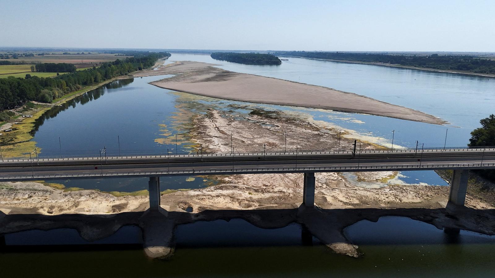
LondonLast week, 186 passengers on a river cruise ship from the company Viking Cruises had to be evacuated by Bulgarian border police after the ship Viking Ullur ran aground on a sandbank in the Danube. The incident took place near the Bulgarian town of Gomotartsi, in a context of exceptionally low water levels that continue to disrupt river navigation and freight transport in much of Central Europe.
The episode highlighted the impact of a persistent drought on one of Europe's main waterways, but also revealed the extent to which falling river levels are transforming the continent's landscape. Near the Serbian port of Prahovo, on the border with Romania, exceptionally low waters have revealed several Nazi ships. Historians had calculated that up to 200 vessels were deliberately sunk in September 1944 to block the river passage and slow the advance of the Red Army in the Balkans. Now at least twenty of these rusty wrecks are visible from the bank.

The drought has also uncovered other unexpected vestiges. On July 24, in Budapest, authorities had to temporarily close the Margaret Bridge after a World War II bomb appeared near one of the pillars. And paleontologists from the regional museum of Ruse, in Bulgaria, identified remains of a mammoth, including fragments of tusks, a jawbone, and part of a femur, which appeared on July 28 in the small town of Ryahovo, 340 kilometers northeast of Sofia. The lack of water brought all this to light.

If you want to investigate the chart in more detail, open the high-resolution version in another tab.In Serbia, Bulgaria and Romania, hundreds of small boats and numerous cargo ships have been immobilized. In Novi Sad, owners of shipping companies have explained that the river has retreated between 15 and 20 meters from its usual bank, which has practically put an end to the river tourist season. From the bridge connecting Vidin, in Bulgaria, with Calafat, in Romania, local fishermen have assured that they have never seen the Danube so low: in some places it is possible to reach the other bank on foot.
All these unusual images are just the most visible face of a much deeper crisis. The drought affecting Europe in 2026 can no longer be interpreted as an isolated event, nor as a simple meteorological anomaly.
This summer – perhaps not yet comparable to that of 2022 – is already leaving its mark not only as "exceptionally warm but also as extraordinarily dry in Central and Western Europe", according to the analysis of the Copernicus climate service, which has been collected by an report from Imperial College London, published less than two weeks ago, for its assessment. During the months of April to June, large parts of the continent, from the southwest (Portugal) to the northeast (southern Finland), have experienced precipitation far below usual records. July's figures have not improved the situation at all.

Three types of water stress
Drought can be defined in many ways, but "there are three main types that manifest with increasing severity", explains to ARA Anne Van Loon, professor of drought risk and water security at the Institute for Environmental Studies (IVM) at the Vrije Universiteit Amsterdam. "The first is meteorological drought, caused by a lack of precipitation. The second is agricultural, in which soil drying, caused by high evapotranspiration, affects the health and growth of crops. Finally, there is hydrological drought, which occurs when aquifer and river levels drop". In this context, "water availability becomes a problem due to the persistence of these conditions", states the professor.
What is being experienced this summer in a large part of the European continent is a crisis that simultaneously puts pressure on rivers, ecosystems, agriculture, industry, transport, and energy generation. It is the rivers, however, that for centuries have been the great natural highways of Europe, and also cultural axes, which, as has been seen, have become one of the main indicators of the crisis.
The Rhine, which originates in the Swiss Alps and flows into the North Sea, is one of the most important waterways in the world for the transport of goods. In July, several control points in Germany and the Netherlands registered the lowest levels since data exists. The German monitoring system has reported that at the end of July, 44% of the river course measurement stations were offering minimum indicators.
The most sensitive point is Kaub, 45 kilometers south of Koblenz, an authentic thermometer of European river navigation. Last week of last month, the depth available for cargo ships dropped to around 27 to 29 centimeters, touching the historic low of 25.2 cm in 2018. But on Wednesday, August 5th, the decline of the Rhine continued to worsen and has already surpassed the historic lows recorded so far. In Kaub, the navigable depth was 23 centimeters, according to the German Federal Waterways and Shipping Administration (WSV). The limited water depth available forces many cargo ships to operate at only 20% of their capacity, which increases costs because goods have to be distributed among more vessels. The risk of supply chain problems also rises.
The Danube faces an equally worrying situation. Europe's second longest river (around 2,850 kilometers), which flows through ten countries, has recorded exceptionally low levels in several stretches. At the end of July, according to German data, almost 80% of observation points showed extremely low values. In Hungary, the Paks nuclear power plant, the country's only one, had to partially halt production last Sunday due to the decrease in flow, which is used to cool the reactors. Since then, however, water levels have begun to recover slowly.
This Thursday, August 6th, the Hungarian prime minister, Péter Magyar, assured that the situation at the plant had stabilized and expressed confidence that the stopped reactors could resume activity soon. The flow is now nine centimeters above the minimum recorded on Sunday, and rainfall forecasts in the coming days in the Austrian Danube basin could contribute to a further recovery.
In Budapest, the Danube is already 14 centimeters above Sunday's minimum, according to data from water management agencies. However, the relatively good news comes amid an extreme weather situation: the Hungarian capital registered a record temperature of 41.1 degrees on Wednesday, August 5, the highest ever measured. The previous record of 41 degrees was set in June of this same year, 2026.
In Romania, the situation has forced exceptional measures to be adopted to ensure the operation of the Cernavodă nuclear power plant, while in Serbia, the lack of water has affected the cooling capacity of coal-fired thermal power plants. The energy crisis derived from the drought has also reached industry: car manufacturers such as Dacia and Ford have agreed to temporary production stoppages to reduce electricity consumption.

Pressure in the southern basins
Drought and water stress are increasingly affecting European rivers. In France, the Loire and Garonne rivers are registering low flows after months with insufficient rainfall, a situation aggravated by high temperatures and increased evaporation. In the case of the Garonne,, which originates in the Vall d'Aran, the lowest levels are concentrated in the Pyrenean headwaters and the stretch between Toulouse and Agen, with the river subjected to notable pressure, although far from hydrological collapse.
In the United Kingdom, the Thames and the supply systems that depend on its reservoirs – which are, in fact, off-channel retention dams – have officially entered a phase of exceptional drought in its southern basin, where in July rainfall was between 93% and 99% of the usual average.
In the Iberian Peninsula, water stress affects the Mediterranean basin but also the basins of major rivers, such as the Ebro and the Tagus. The situation, however, is not dramatic at present. On the Tagus, reservoirs are at 64.25%, with 7,104 hm³ stored. This is a level higher than the average for the last ten years for this week (55.12%), but lower than for the same week in 2025 (74.41%). In stretches like Toledo and Talavera de la Reina, according to data from the El Tejar station, the flow is 22.6 m³/s, a normal value for the station.
On the Ebro River, increasing pressure on water resources is also observed. Although snowmelt contributions from the Pyrenees have been much more abundant this year, the combination of high temperatures, evaporation, and agricultural demand maintains a state of vigilance in various stretches of the basin. Reservoir levels are at 64.86%, with 5,060 hm³. In this case, it is a figure slightly lower than the average for the last ten years (66%) and well below the same point in 2025 (71.65%). Water management continues to be particularly sensitive in tributaries such as the Segre and Cinca, where reserves and irrigation allocations condition agricultural activity.
The Po, in Italy, is again registering exceptionally low levels and flows this week, in line with the historical lows of 2003 and 2022. In Pontelagoscuro, at the delta, the flow is around 300 m³/s, well below the 450 m³/s considered the critical threshold for limiting saline intrusion. In Cremona, the Po has already reached a historical low this summer of -8.53 meters with respect to the hydrometric zero, slightly below the record of -8.52 meters registered in 2022. All this confirms an early and persistent drought (low water period), fueled by the lack of alpine snow, irregular rainfall, and thermal anomalies that characterize recent years.
The decrease in flow has caused a particularly worrying phenomenon: the penetration of saltwater from the sea into the interior of the river. When the pressure of the river current decreases, seawater can advance more than 18 kilometers upstream along the Po riverbed and salinize aquifers, alter ecosystems, and make water use for crops impossible. Compared to the recent past, 2026 stands out for the earliness and intensity of the drop in levels: the lows arrive earlier, last longer, and affect the entire basin more acutely.
A completely different context
What is changing today is the climatic context: global warming alters the starting conditions – higher temperatures, less snow, more evaporation – and causes episodes that were previously occasional to have a more profound and sustained impact. The Po, Italy's longest river and the country's main agricultural axis in the north, has become another symbol of the water crisis affecting the European continent.

The aforementioned Imperial College study concludes that climate change caused by human activity "has significantly increased the risk of drought in Europe". The rise in temperatures has caused the atmosphere to extract much more water from the soil and vegetation, "which accelerates the drying of the land". Compared with a 1.4°C colder climate, soil droughts are now about five times more likely in Western Europe and between eleven and eighteen times more likely in Eastern Europe. If global warming reaches 2.8°C compared to pre-industrial times, the risk will continue to increase significantly.
The evolution of precipitation will not be the same across Europe, but while a slight decrease in rainfall is predicted in the west, it could even rain more in the east. However, this increase will not compensate for the effect of higher temperatures, which cause more water to evaporate and dry out the soil more quickly. Furthermore, observations show that these processes are advancing even faster than many climate models predict, so the authors warn that the risk of drought could be even higher than current estimates indicate. Europe's rivers may expose many more vestiges that were previously underwater.
