Atlantic storms will cause new changes in the coming days
The rainiest day will be Thursday, and the temperatures will be high for the dates

-
CAT -
CAST

We have started the week with many clouds and light, scattered showers or drizzles that have been crossing the country from west to east, leaving very little water. Temperatures have been very mild in general, with a thermal rise that has been very marked at night. Atlantic storms will not give a respite in the coming days, with weather that will remain very changeable.
Tuesday and Wednesday there will be more periods of sun and little rain, with thermometers reaching their peak. The atmosphere will be warm for the time of year, fulfilling the tradition of St. Martin's summer. But starting Thursday, in addition to the Bruna storm, another one with tropical characteristics will arrive that will cause a round of rain. Subsequently, the north wind will enter and temperatures will drop, with a more autumnal atmosphere at the end of the week.

Tuesday: very mild atmosphere
This Tuesday we will wake up again to a mild atmosphere and maximum temperatures will rise even further. Many values between 20 and 25 ºC are expected, with the highest in the Terres de l'Ebre. All this with a sky veiled by the passage of bands of high and mid-level clouds, which will combine with the sun.
In the afternoon and evening, some light showers will arrive in the regions of Lleida and the Ebre, especially on the southern side of the Pyrenees and the western Pre-Pyrenees and nearby areas. Not much in principle. The south-westerly wind will strengthen in the afternoon on the coast.

New change in weather in the middle of the week
On Wednesday, the sky will remain changeable, and in the late afternoon, some showers will return to the Lleida regions. On Thursday, the passage of the new Atlantic storm will bring precipitation to our area. Outside of the southern side of the Pyrenees and the Pre-Pyrenees, not much rain is expected, while in the western half of the Peninsula, the rain will be very heavy.
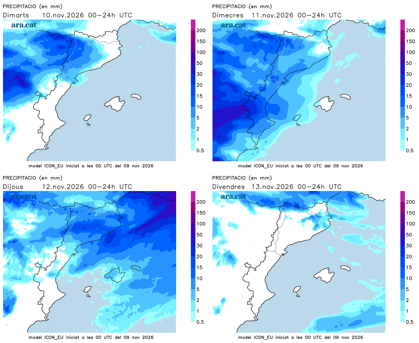
The west wind will strengthen temporarily, with an atmosphere that will still be very mild. In fact, on Wednesday the atmosphere will be warm, with a peak in temperatures and values clearly higher than usual for this time of year. Precisely, it will be Saint Martin's Day. But once the storm passes, a north wind will enter that will sweep away the warm air, and the second half of the week is expected to be much cooler.
