Weather for the Diada long weekend: a fairly calm start, but showers will return.
Sunshine and calm will gain ground in the coming hours, but along the bridge its instability will increase again.

BarcelonaWe're leaving behind a very erratic spell of showers and heavy thunderstorms. Rainfall varied widely between Monday and Tuesday, but in some places, local rainfall reached between 50 and 100 l/m², with a few downpours (you'll find all the data at the end of this report). Calm and sunshine will gain ground this Wednesday, although there will be some exceptions in Catalonia and the Balearic Islands. We wake up to a markedly cooler atmosphere overall, even cold in the Pyrenees, but midday will be warmer. Thursday, Catalonia's National Day and a public holiday, will be a placid day in most regions, but scattered showers may occur in parts of the Pyrenees and between Girona and Barcelona. Showers will begin on Friday, right during the long weekend for many people. Therefore, the next few days will be a mixed bag. Maximum temperatures will rise, but the heat will be moderate and normal for the time of year, with nights that remain cool.

Wednesday: more sun and calm
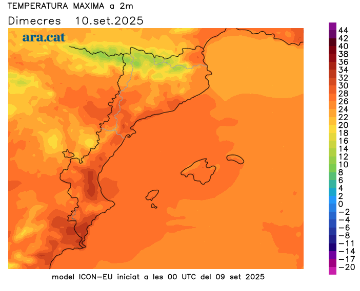
The weather will be mostly calm this Wednesday, with plenty of sunshine and calm in most regions. However, there will be minor variations. Early in the morning, there will be remnants of cloud cover in the northeast, with the occasional scattered shower possible, especially along the coast. Scattered showers will also arrive in the Pyrenees and northern Girona, particularly in the Alt Empordà region, in the afternoon. However, no rain is expected elsewhere, and the Tramuntana and Mistral winds will only blow until mid-morning or midday in the Empordà and Ebro regions.
Regarding temperatures, minimum temperatures have generally dropped, with cooler mornings everywhere, including along the coast. Only in the northeast has the presence of clouds halted a more pronounced drop in temperatures in this area. It is even cold in the Pyrenees, especially at the highest elevations, although in the valleys temperatures have also dropped below 10°C. Many minimum temperatures have ranged between 11°C and 16°C inland and on the pre-coastal areas, and below 20°C on the coast. Maximum temperatures will rise thanks to more sunshine, especially on the central and southern coast and pre-coastal areas, but the heat will be moderate. Most records will range between 23°C and 28°C, with some locally reaching 30°C.
Diada Bridge with a little bit of everything
The Diada will be marked by calm in most regions, but not everywhere. The arrival of more humid winds from the sea inland on the coast and the pre-coastal areas of Barcelona and Girona will increase cloud cover in these areas, with the risk of some scattered showers. There may also be some irregular showers in the Pyrenees. However, for the rest of the country, the festive day will be enjoyable, with a normal warm atmosphere for the season in the middle of the day and cool mornings.
However, the maps indicate that instability will increase again towards Friday due to the passage of a new front, which will bring showers back to several regions. This is a still uncertain situation that we will have to specify, but it would occur right in the middle of the Diada long weekend, when many people celebrate and go out. The weather will not clear completely over the weekend, and temperatures will experience some ups and downs, but they appear to remain in line with the mid-September normals.
Balance of showers and strong storms
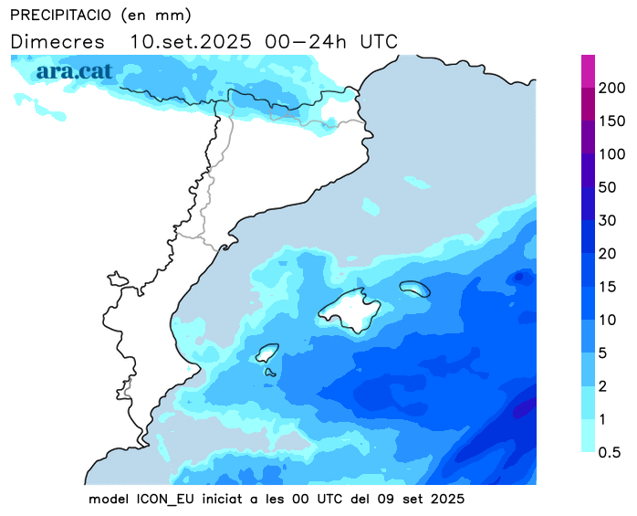
The active cold front that arrived at the start of the week caused a marked increase in instability. Between Monday and Tuesday, the weather was very unsettled, with little to no rain falling everywhere, albeit very irregularly. The most extensive rainfall occurred during the early hours of Tuesday morning, and there were areas where showers and thunderstorms were intense and abundant.
The areas most affected by the intense rainfall were the Pyrenees and Pre-Pyrenees (especially the eastern one), points in the northeast, central Catalonia, the Ebro River, and between Camp de Tarragona and the southern coast and pre-coast of Barcelona. In these areas, total levels ranged from 50 to 100 l/m². This water has helped to somewhat recover the reservoirs in the inland basins after the summer decline. They are currently at 73%. There were also some notable downpours in the Valencian Community and especially in the Balearic Islands, where strong gusts of wind caused damage and trees fell due to snapping. These are some of the most notable records from the entire episode in Catalonia:
- 115 l/m²: Aleixar
- 109 l/m²: Beget
- 95 l/m²: The Squirrel-Cantonigroso
- 84 l/m²: Almadraba de Bages
- 82 l/m²: the Camp Forest
- 81 l/m²: Orís
- 76 l/m²: Berga
- 69 l/m²: Mas de Barberans
- 62 l/m²: Mieres
- 61 l/m²: Port del Comte
- 61 l/m²: Sau reservoir
- 60 l/m²: Sant Martí Sarroca
- 59 l/m²: Torredembarra
- 59 l/m²: Prats de Lluçanès
- 59 l/m²: Hospitalet de l'Infant
- 58 l/m²: Casserres
- 56 l/m²: Pierola Hostalets
- 56 l/m²: Perafita
- 56 l/m²: El Vendrell
- 55 l/m²: Tamarit
- 54 l/m²: Montesquiu
- 53 l/m²: Artés
- 53 l/m²: Lladurs
- 52 l/m²: Fillers
- 52 l/m²: Villa-round
- 52 l/m²: Montserrat
- 52 l/m²: Miami Beach
- 50 l/m²: Queralt sanctuary
- 50 l/m²: San Pablo de Segúries
- 45 l/m²: Riudecanyes
- 41 l/m²: Oliana
- 41 l/m²: Constantine
- 41 l/m²: the Quar
- 38 l/m²: the Tallada of Empordà
- 36 l/m²: Rápita - Els Alfacs
- 36 l/m²: La Pobla de Segur
- 36 l/m²: Tempering
- 35 l/m²: Ulldecona
- 35 l/m²: Vinyols and els Arcs
- 34 l/m²: Darnius-Boadella Swamp
- 33 l/m²: Girona
- 32 l/m²: The Pont de Suert
- 31 l/m²: Molló
- 30 l/m²: Castellar de n'Hug
- 30 l/m²: Luck
- 30 l/m²: Old
- 29 l/m²: Organyà
- 28 l/m²: Banyoles
- 26 l/m²: Saint Peter the Fisherman
- 25 l/m²: Olot
- 23 l/m²: La Seu d'Urgell
