Towards an increasingly cold and autumnal environment
Temperatures will be going down over the next few days, with a little more instability

-
CAT -
CAST
BarcelonaThe thermometers have started to drop in these last few hours. Today we are already waking up to a much more marked coolness or cold, while yesterday the mildness marked at midday was still repeated, with many highs of 20 to 25 °C, locally up to 26 °C in the southern interior. Little by little we are leaving behind the 'little summer' of the last few days. And that is because during the second part of the week the core of the anticyclone will be located between central and northern Europe, a fact that will push colder northeasterly winds towards us. This will cause the thermometers to fall, waiting for a cold 'Castanyada' like the ones of a lifetime. All this with a rebound in instability that will leave some showers on the coast, the Ebro and, above all, in the Valencian Community and the Balearic Islands. Next week the cold could become even more evident.

Thursday: lower temperatures
The drop in temperature that began on Wednesday will continue this Thursday. Temperatures will fall, both by day and by night. In the early hours, there are values below 15 ºC on the coast and 10 ºC inland. And the maximums will drop, especially on the coast and the pre-coastal area. Many values between 18 and 23 ºC are still expected, slightly higher in the southern interior. The tramontana wind will blow between light and moderate in the Empordà.
Be that as it may, we will have quite a lot of calm and sun, but with nuances. From dawn and during the first hours of the morning, intervals of low clouds will remain in parts of the central coast and pre-coastal area and the Costa Brava, without ruling out some local light rain. There will also be many morning fogs inland. During the afternoon, bands of high and thin clouds will arrive from the west that will spread in a westerly direction, while there will also be some harmless low clouds in coastal sections. Only on the island of Mallorca are some showers expected.

Increasingly autumnal atmosphere
Temperatures will continue to drop over the next few days, and we will reach the All Saints' Day weekend with normal values for this time of year, even slightly below what would be expected. This will translate into afternoons that are between cool and mild, and cold nights everywhere. Therefore, the night of the Castanyada will be like those of the past, with a cold that will invite you to eat panellets and chestnuts by the fire.
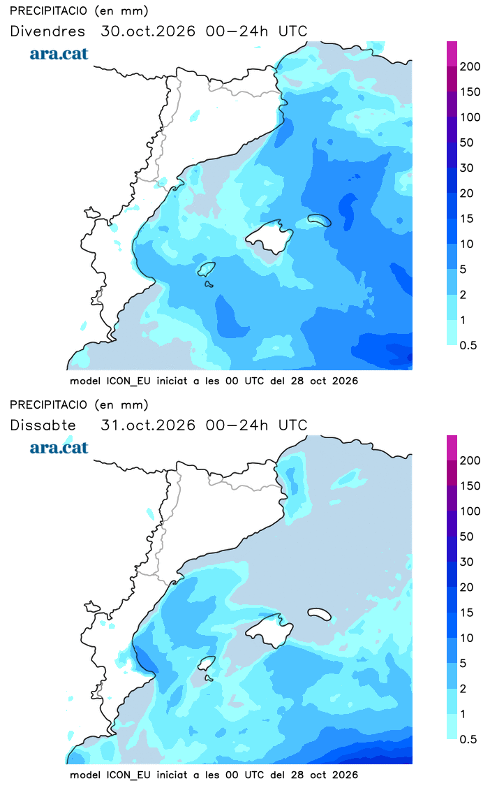
This situation will be accompanied by humid winds from the northeast and east throughout our Mediterranean area which, together with the presence of cold air at high altitude, will cause an increase in instability. It will not rain in most of Catalonia, but between Friday and Saturday showers will arrive in the Ebro region that may temporarily affect some other coastal stretches. There will also be downpours in the Balearic Islands and the Valencian Community, and the most significant rain is expected in Valencia.
Looking ahead to next week, the maps indicate that temperatures will drop even further. We could even have an atmosphere of late autumn and early winter air. A coldness that will be the result of the irruption of very cold air that will affect Eastern Europe and that, indirectly, will be felt in our region.
