Busy weekend with new rains
The downpours and the storms will affect above all the coastline, the pre-coast, the northeast and the Pyrenees

-
CAT -
CAST
BarcelonaThe rainstorm has fully affected the Terres de l'Ebre and the north of the Valencian Country since Thursday, with many accumulations of 100 l/m² to 200 l/m². But in some cases more water has fallen, for example in municipalities of Montsià and Baix Ebre. Notable are the more than 270 l/m² in l'Ametlla de Mar, the more than 230 l/m² in Alcanar, or the more than 220 l/m² in Mas de Barberans. Water often fallen in a torrential manner in a few hours that has caused floods, flash floods, and many incidents. It has also rained with less intensity in many other points of the center, south, and west of the country, with less significant amounts.
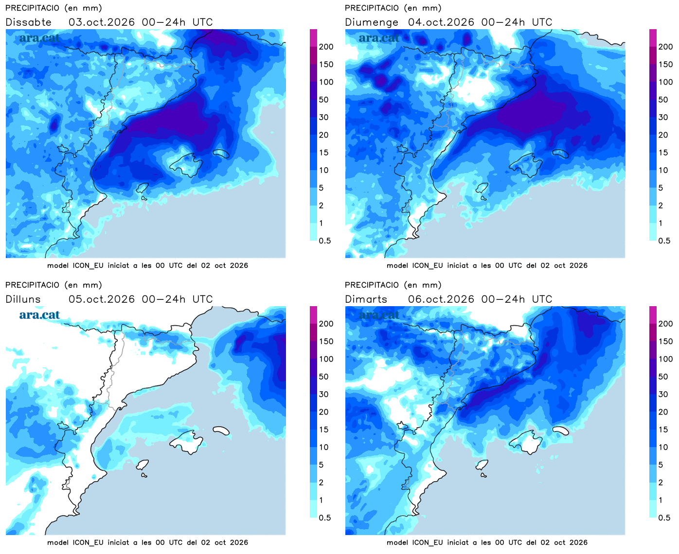
And attention, because this weekend the weather will remain unsettled and with new precipitation and storms, especially on the coast, the pre-coastal area and the northern half. We continue throughout our Mediterranean zone under the effects of instability, due to the arrival of humid winds from a sea that is still very warm which are combined with cold air at altitude.

Saturday: new showers and storms
The rain will give a respite to most counties this Saturday morning, although showers and some downpours may arrive from the early hours in the Valencian Community and the Terres de l'Ebre. It will be from noon and during the afternoon when new showers and irregular storms are expected in many places, especially on the coast, the pre-coastal area, Central Catalonia, the Pyrenees, the Pre-Pyrenees and the northeast. Rain that can be heavy, which is why Meteocat maintains the alert for intensity in many counties, both Saturday and Sunday:
In the rest of the Valencian Community and the Balearic Islands, some more scattered showers may also fall. All this with temperatures that will rise in Ponent and the Ebre, but will drop in Barcelona and Girona. Heat kept in check and nights between cool and mild, with sea winds.
Sunday: more rain
With a bit of uncertainty still, the maps indicate that on Sunday the precipitation may be more continuous in many parts of the coast, the pre-coastal area, and the northeast. A day that will be quite gray again and is unlikely to bring rain to the Lleida regions, where there will be plenty of clearings. Some downpours may become intense again.
Next week the weather will remain quite unsettled with a bit of everything and a rollercoaster of temperatures, which will experience rises and falls depending on where the wind blows from. The days it may rain the most would be especially Wednesday and Thursday, although everything will have to be confirmed as we go along.