The powerful subtropical storm 'Charles' arrives: how will it affect Catalonia?
Regarding temperatures, they will hit a ceiling and the peak of Saint Martin's summer will be experienced


-
CAT -
CAST
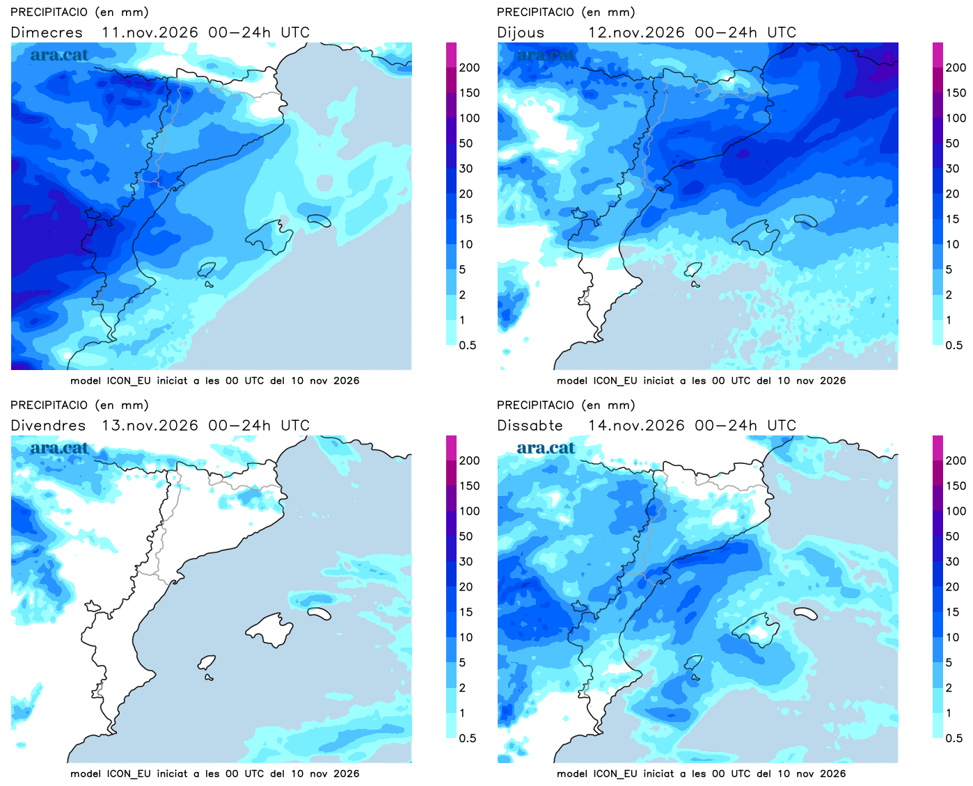
BarcelonaAtlantic storms give no respite, and between Wednesday and Thursday, the main event of this situation will occur. Before that, however, between this evening and tonight, new showers will arrive from the West that will especially affect the southern face of the Pyrenees and Pre-Pyrenees of Lleida, where the rain could be somewhat more significant. In the rest of the country, some drizzles or weak, scattered, and passing showers that will move rapidly from west to east cannot be ruled out.
We have spent days under the effects of the storm Bruna –anchored in the Atlantic– and now storm Charles will enter the scene, which will cause important changes. It is a disturbance of subtropical origin loaded with humidity that, upon reaching the Peninsula and interacting with Bruna, will deepen. On Wednesday, very heavy rains and strong winds are expected in the southwestern peninsula, where damage can be caused and up to 200 or 300 l/m² can accumulate: there are many alerts activated. And from tonight until Thursday, the storm will cross Catalonia, with precipitation and strong westerly winds. Wednesday will also see the peak of temperatures and the 'St. Martin's Summer', with a very mild or warm environment for this time of year. However, at the end of the week, a north wind will arrive that will cause thermometers to plummet.

Wednesday: day of impasse
The sky will continue to change, remaining between overcast and partly cloudy this Wednesday due to the passage of bands of high and mid-level clouds. At times, the sky will even become more clouded, especially in the western half of the country. There will also be a lot of morning fog. For most of the day, no precipitation is expected, although a few early showers or sprinkles cannot be ruled out in the regions of Lleida. However, starting in the late afternoon, new precipitation will arrive from the west. Throughout the day, we will also have to be very attentive to the havoc caused by the storm Charles in the southwestern peninsula, where heavy rain and strong winds are expected.

Rain will be significant and abundant on the southern side of the Pyrenees and the Pre-Pyrenees from the evening until Thursday morning, especially in the western part. During the night, this rain may affect any part of the country, moving again from west to east. Meteocat has activated an alert for accumulations of more than 100 l/m² in 24 hours in the Val d'Aran, Alta Ribagorça, Pallars Sobirà, and Pallars Jussà.
Temperatures will peak, with little morning chill and a very mild or slightly warm atmosphere in the middle of the day. Most highs will range between 22 °C and 26 °C, with the highest in the coastal and pre-coastal areas, due to the reheated wind from the south and west.
The effects of the storm ‘Charles’ are arriving
Thursday will be a busy day due to the arrival of the effects of the powerful Atlantic storm Charles. During the night and the morning it may rain anywhere, although outside the southern face of the Pyrenees and the Pre-Pyrenees no significant amounts are expected. This storm will reactivate the westerly wind, which will blow for a large part of the day with force, with locally strong gusts. Meteocat also has alerts activated for strong winds and for maritime storms, especially on Thursday.
A wind that will arrive reheated on the coast and in the south, where at night the atmosphere will be mild and during the day the values will remain clearly high for the time of year. On the other hand, inland and in the Pyrenees the thermometers will already begin to drop. A drop that will become widespread between Friday and especially the weekend, with the sudden return of full autumn weather and traces of showers in the north of the country.