Storm Ingrid is bringing showers, snow, strong winds and intense cold this weekend
The snow level is plummeting and it is snowing in areas outside the Pyrenees, near 400 m
BarcelonaThe unsettled weather offers no respite, and this weekend will bring the peak of the effects of the powerful Atlantic storm. Ingrid At our house. It will rain everywhere this morning, and in the afternoon the showers will be more concentrated in the northeast and the Pyrenees. Be careful with the snow level, as it will drop to 800 or 600 meters – and locally lower – and we will see snow outside the Pyrenees at relatively low elevations. A blast of cold air will arrive, causing temperatures to plummet, with a distinctly colder and more wintry feel. Sunday will be changeable, with a new front expected from the afternoon onwards. All of this will be accompanied by strong winds in various regions.


Saturday: Showers and snow outside the Pyrenees
Today the main course of the effects will arriveIngrid In our country, a small secondary low-pressure system associated with the same storm will develop, complicating the weather. Showers are expected throughout the morning, moving from south to north. The heaviest rainfall is expected in the northeast and the Pyrenees, where unsettled weather will continue throughout the day, with more rain and snow. So far, 17 liters per square meter have already fallen.2 in El Vendrell, 12 l/m2 in Torredembarra and 12 l/m2 in Tárrega.
Meteocat has issued a warning for heavy rainfall (up to 100 l/m²).2) in the Alt Empordà. Be aware of the risk of flash flooding in this area due to streams and flood-prone zones.

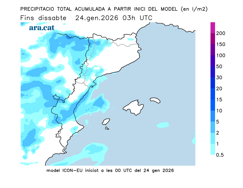
Be careful with the snow level, as it will plummet. It will drop from the initial 1000 m to 800 or 600 m. Even during periods of heavier rain, snow may fall as low as 500 or 400 m. Therefore, beyond the Pyrenees – where it will snow at all elevations – snow will be seen again across much of Montseny, Albera, Montnegre, the Transversal Range, and Montsec. Generally, accumulations of between 20 and 30 cm are expected today in the Pyrenees above 1500 m, and between 10 and 20 cm in the Pre-Pyrenees, Guilleries-Collsacabra, and northern Central Catalonia. The storm will pass quickly, and in its wake, strong north-northwest winds (with blizzard conditions in the Pyrenees) will arrive from mid-afternoon onwards.
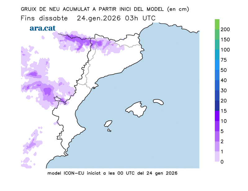
Less frequently, snow is also expected at higher elevations in other pre-coastal mountain ranges, such as Montserrat, the Prades Mountains, and the Sant Llorenç del Munt i el Obac and Els Ports Natural Parks. Therefore, exercise caution today due to snow in the Pyrenees and Pre-Pyrenees valleys and other less common areas. It is essential to ensure your vehicle is properly equipped to avoid any surprises. Meteocat has issued an alert for snow accumulations exceeding 5 centimeters above 700 meters in several inland regions.
Showers and thunderstorms are also expected in the Balearic Islands, all accompanied by a significant drop in temperatures. Many areas are forecast to have lows of only 6 to 12 °C, with significantly lower temperatures in mountainous regions. In fact, high mountain areas will experience freezing temperatures, with sub-zero temperatures throughout the day.

Caution is also advised due to the strong winds, ranging from mistral to westerly, which will gradually intensify and affect central and southern Spain, the Empordà region, and the higher elevations of the Pyrenees, where blizzard conditions are expected. These winds will also be particularly strong in the Valencian Community and the Balearic Islands, with rough seas along the entire coast.
Sunday: waiting for a new front
The last day of the weekend will dawn with a cold, harsh winter feel, with frost outside the windier areas. A sunny and windy morning awaits us in the southern half of the region, in the northern Empordà, and at higher elevations. It will be a day of relative calm with slightly higher maximum temperatures, as we await the arrival of a new front in the afternoon and evening, which will bring renewed snowfall across the Pyrenees and wind to many areas. More showers are also expected in western areas, the Pre-Pyrenees, and surrounding regions.

He won't clean up next week.
Medium-range forecasts indicate that the weather will remain very changeable and unsettled next week due to the passage of new Atlantic fronts. Therefore, the sky will be very changeable, with further showers, strong winds, and fluctuating temperatures.

