Red alert in several counties for the new round of downpours
Some storms may be locally strong, although without any new extraordinary episode of rain like the one from the weekend

-
CAT -
CAST
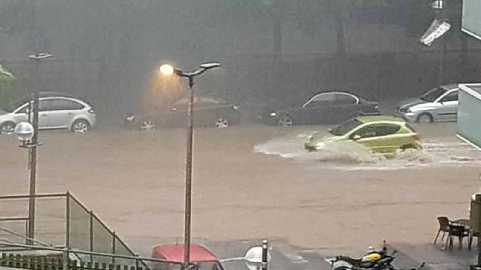
BarcelonaA new week begins that will once again be marked by unstable weather throughout our Mediterranean area. The truth is that the rain and downpours on the coast and pre-coastal areas this Monday morning are much more significant than initially forecast. The most affected region is the Vallès Oriental, where more than 100 l/m² have already fallen in a short time in some cases. In Granollers, for example, more than 80 l/m² have fallen in just one hour. Since it is raining on wet ground, all of this has caused serious flooding, and a risk of rivers and streams overflowing. For this reason, confinement has been requested in this region. Meteocat has activated a red alert for the entire coast and pre-coastal area of Barcelona and La Selva due to intense rain. More than 40 l/m² can accumulate in half an hour, or more than 90 in three hours.

Therefore, Monday will be very much about keeping an eye on the sky, especially until midday. It is worth noting that this week, according to the maps, a new episode of torrential rain as extraordinary and widespread as the one over the weekend is not expected (you will find the most notable data from this historic storm at the end of this report), but showers and thunderstorms will return to fall irregularly in various regions. This afternoon the situation should improve, although there will remain some scattered showers in parts of the Pyrenees, Pre-Pyrenees, Ports and, more locally, in Central and pre-coastal Catalonia. They may be locally strong and dump heavy rain in a short time. In the coming days, showers will continue to repeat here and there. Temperatures will undergo small rises and falls, but the week could end with a more significant cooldown.

Monday with a hangover from a historic episode
During the early hours, instability has increased again, and this morning showers and thunderstorms have reappeared along the coast and pre-coastal areas. Locally, some of these showers are intense and torrential, accompanied by storms. On the other hand, towards the interior, the morning will be quite calm, with much more sun or clearings towards the west. Banks of low clouds and scattered fog will also appear in plains and valleys. Thermometers will recover a little at midday. In the northeast, the thermometer will rise a little more, with values that will range between 22 ºC and 26 ºC.

During the afternoon, clouds will grow due to the proximity of a cold air pocket coming from the Atlantic. They will appear downpours, scattered in nature, also in the form of a storm. Showers will fall in the Pyrenees, the Pre-Pyrenees -especially in the oriental- and the Ports, but they will also discharge some in the pre-coastal area and in some points of the northeast.
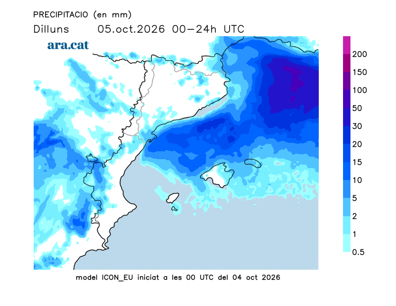
The Meteocat alerts are for intense rain and accumulations of more than 40 l/m² in half an hour or, locally, 60 l/m² in three hours in some regions. The maximum danger level is 4 out of 6:
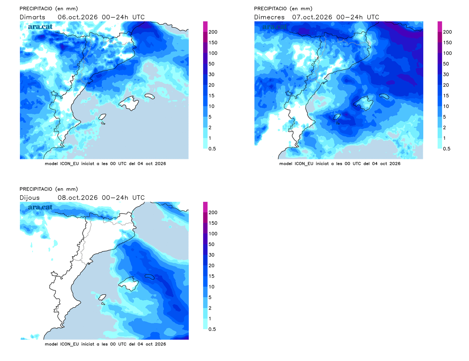
Unsettled week, with new showers
With the approach of the cold air pocket, the weather will become complicated again and will be unsettled. Tuesday and Wednesday will see a return of showers and some thunderstorms, more likely in mountain areas, in inland Catalonia and the pre-coastal region. It will not fully clear up until the end of the week, and temperatures may drop towards Friday, especially inland and in the Pyrenees, where it will be cooler.
These situations of marked instability, like the one experienced this weekend, are typical of autumn, aggravated by a sea much warmer than it should be at this time of year. This year, records have been set for the average sea surface temperature in the Mediterranean, which reached 28.6 °C on August 14, according to data from the Copernicus Marine Service. In Catalonia, the sea has reached its highest average temperature ever recorded this summer: 21.1 ºC.
Balance of a historic rainstorm
An extraordinary mesoscale convective system has generated torrential rains this weekend, especially in the pre-coastal and coastal areas of Barcelona and Girona, with exceptional amounts such as, for example, the 288 l/m2 in Vilassar de Mar, the 255 l/m2 in Mataró (Can Canyelles) and the 248 l/m2in Granollers. Even some unofficial stations have recorded around 300 l/m² in municipalities such as Cornellà. Spectacular figures that, furthermore, were recorded mostly in just six or eight hours.
Finally, the medicane (Mediterranean mini-hurricane) did not form. But, as the models indicated, the amount of accumulated rain was historic in just a few hours. Notable are the 68 l/m² that fell in just half an hour in Granollers, a figure of extraordinary torrential intensity. The storm system fully affected the Maresme and the Vallès Occidental and Oriental regions, with much destruction, flooding and, unfortunately, two fatalities and one missing person. In the city of Barcelona (Can Bruixa), the record for accumulated precipitation in 24 hours was broken (data since 1914), with a total of 213 l/m2.
The torrential intensity and the exceptional amount of water accumulated in a few hours caused the flow of the Besòs river to reach 937 m³/s on Sunday morning in Santa Coloma de Gramenet, almost double the more than 500 reached during the Gloria storm. To give us an idea, the flow of this river (which normally carries 20 m3/s) reached three times the water of the Ebro river. Early on Sunday, there was a hydrological alert for possible overflows mainly in the Besòs and the Tordera, as well as in other rivers in the northeast.
These are the most notable records, according to Meteocat stations, between Saturday and Sunday morning, with the majority of liters falling between Saturday evening and Sunday dawn.
