This week we will breathe much easier: a clear refreshment is coming
The most significant change in weather is expected on Wednesday, with showers and storms in various regions.

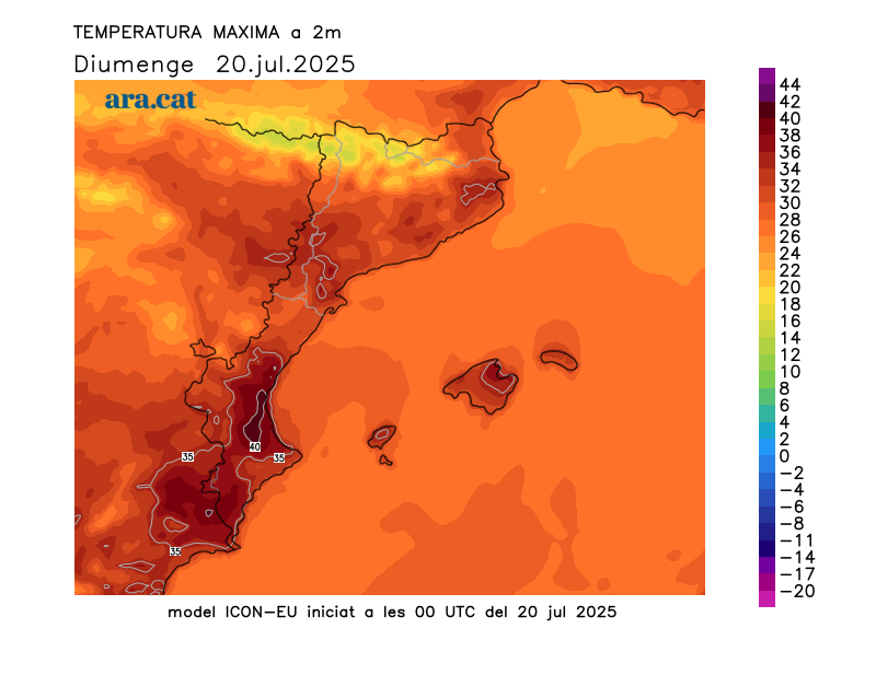
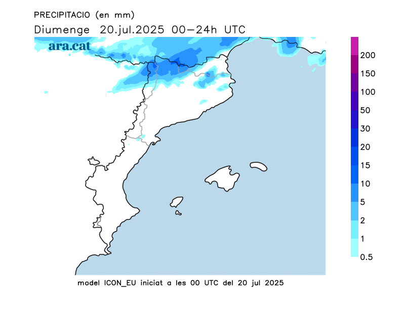
BarcelonaThe approaching Atlantic front will send some cold air aloft, causing temperatures to drop slightly this Monday. This will be a slight respite from highs that soared again yesterday, especially in the south of the country (at the end of this report, you will find a brief list of the highest temperatures recorded yesterday). Last night, some downpours fell in the north and west of the country, resulting in, for example, 17 l/m² in Espot and 15 in Bonaigua (Pallars Sobirà), 12 in Vielha (Vall d'Aran), and 11 in Organyà (Alt Urgell) and Núria (Ripollès).
It was another heavy night, with poor sleep in many parts of the coast and pre-coast, with muggy conditions. But this week, the news will be that temperatures will drop and return to normal, with the muggy conditions also clearly easing. Starting Wednesday, the mercury will experience a drop to below-season levels, with a manageable and very bearable heat during the day and cool temperatures at night. A prime setting for the summer heat wave. Wednesday will also see a surge of cold air, increasing instability, with showers and thunderstorms likely to hit many areas.

Monday: temperatures drop slightly
Once again, minimum temperatures have remained above 20°C in many coastal and pre-coastal areas, as well as in some areas of southern inland. The atmosphere has been heavy, especially along the coast, with muggy conditions and some new torrid lows—above 25°C—in large urban areas, particularly in the center of Barcelona. However, much of the inland and the Pyrenees enjoyed a good night's sleep, with overall minimum temperatures dropping.
Today, maximum temperatures will drop everywhere, especially in coastal and pre-coastal areas—especially Girona—and in southern inland areas. Many temperatures will hover between 27 and 33°C, but inland along the Ebro and in the Ponent region, temperatures will still hover around 34 or 35°C. In any case, the heat is far from extreme.
The early morning showers in the north and west of the country are now history, although a few drops or localized sprinkles may occur in the northeast during the morning, and these could repeat in the afternoon inland areas of this region and in the eastern Pyrenees, with only a few clouds in the northeast and the Pyrenees. Tramuntana and mistral winds will blow in the Empordà and Ebro regions, especially in the morning, with rough seas on the northern Costa Brava.
Waiting for a major change on Wednesday
Tuesday will be a calm day with a temporary rise in temperature. On Wednesday, the arrival of a pocket of cold air from high altitude will increase instability, with showers and thunderstorms reappearing irregularly in virtually every region. Locally, they will be of moderate to strong intensity and will be accompanied by hail, strong gusts of wind, and, in some cases, hail. But above all, this change in weather will pave the way for a clear drop in temperatures. From then on, we can expect days with mild heat and muggy weather, as well as cooler nights. Below-average values, with moderate and luxurious temperatures, will be a welcome change for the end of July. We'll breathe much easier after so many days of sweltering heat and muggy weather.
Maximum temperatures recorded on Sunday:
- Vine: 38.5 ºC
- Benissanet: 37.9 ºC
- Siurana Reservoir: 37.4 ºC
- Masroig: 37.4 ºC
- Torroja del Priorat: 37.2 ºC
- Falsillo: 36.6 ºC
- Aldover: 36.4 ºC
- Serazo: 36.4 ºC
- Ribarroja Reservoir: 36 ºC
- Segre Towers: 36 ºC
- Lleida: 36 ºC
- 35 ºC
- Olot: 34 ºC
- Temper: 34 ºC
- Empordà carving: 33 ºC
- Viladecans: 33 ºC

