October begins with almost the whole country on alert for strong storms
Strong storms will affect many regions, but the most abundant rains will leave more than 200 l/m² in the Ebro and the Valencian Country

-
CAT -
CAST
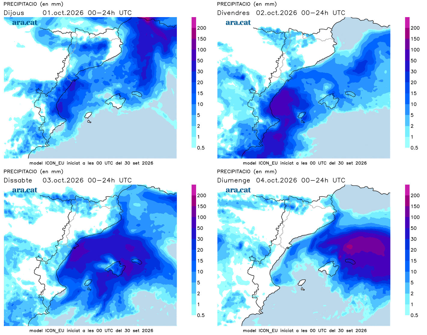
BarcelonaThis Thursday we will have to be very attentive to the sky again. October begins today with an increase in instability, as showers and thunderstorms will gain ground irregularly in several regions. The main event is expected from midday and during the afternoon, when torrential downpours may occur. The areas most affected will be the Terres de l'Ebre, Castellón, and the coast of Valencia, where between today—especially from the evening onwards—and tomorrow, a period of significant, intense, and persistent rain is expected. The accumulations will be significant and may locally exceed 200 l/m² throughout the episode, with sudden downpours and a risk of flooding. Aemet has activated a red alert in these areas, with extraordinary accumulations that may exceed 150 l/m² in just six hours. However, Meteocat has also placed the Camp de Tarragona, the Penedès, and the Garraf on red alert due to the afternoon downpours.
All of this is the result of the combination of cold air at high altitude with the entry of humid maritime winds, driven by an anticyclone located further north. Thermometers will be dropping over the next few days and, little by little, they will normalize.

Thursday: storms in some places
Instability will increase this Thursday, the first day of the month of October. A day of variable and changing skies, with the first showers in the morning in the Pyrenees and between the Costa Daurada and Barcelona. It will be in the afternoon when downpours and storms will regain ground. They will fall irregularly and will mainly affect points in the Pyrenees, the Pre-Pyrenees, Central Catalonia, the pre-coastal area, the Terres de l'Ebre and the Camp de Tarragona. However, the latest map updates increase the risk of locally intense thunderstorms also on the coast and pre-coast of Barcelona.

In the afternoon, the rain will reactivate in the Ebro, in Castellón, and in Valencia, where it may be intense, persistent, and very abundant: locally, more than 200 l/m² could be exceeded until Friday. Storms will also reach Ponent as the hours pass. Meteocat has activated an alert for a large part of the country due to intense rain that may locally leave more than 40 l/m² in half an hour or more than 60 or 90 l/m² in three hours, especially in Central Catalonia, the Pre-Pyrenees, and the Terres de l'Ebre. The alerts are red -the maximum possible level- in Camp de Tarragona, the Penedès, and the Ebre.
On the other hand, the maps indicate that the rain will pass more lightly over the central and northern coast, while in the afternoon the meteorological situation will also become complicated in more parts of the Valencian Community. Some local showers will also escape in the Balearic Islands. All this with the arrival of the tramontana in Empordà and the strengthening of maritime winds along the rest of the coast, with temperatures that will drop.
Unsettled and autumnal weather
On Friday, the main brunt of the rain will be concentrated in the Valencian Community and the south of the Terres de l'Ebre, where downpours may occur and significant water accumulations may be recorded. In the rest of Catalonia and the Balearic Islands, little rain is expected, with variable skies. On the other hand, there is still much uncertainty about whether the precipitation will move to Catalonia on Saturday. A point that we will have to confirm. Thermometers will drop, with increasingly cool autumn weather.