A day of impasse, waiting for a change in the weather, with rain and a drop in temperature.
A front will bring storms and cooler weather starting tomorrow.

BarcelonaThe weather will change significantly starting tomorrow, with the arrival of a front associated with a powerful storm (ex-hurricane Erin). The cold air it will bring will connect with the mild climate and the warm air over the Mediterranean and will cause powerful storm clouds to form. We should be very alert to this situation because some showers and strong thunderstorms could occur. However, Tuesday will still be a day of stagnation or turning point, with many clear spells and a warm atmosphere.
Of the last few hours, the rain front—with light amounts—that affected the Catalan regions from south to north on Monday stands out. Generally, between 1 and 2 l/m2, and in many cases, tenths of a litre (at the end of this information you will find the most notable accumulated records).

The morning will be sunny to partly cloudy, with some high and medium-high clouds. Low clouds will appear early on the coast, especially along the Ebro and the Costa Brava. From midday on, cloud cover will increase in the West, and showers may occur in the Lleida Pyrenees. These will be the first signs of instability associated with the approaching frontal system.

Temperatures will rise slightly further in the West, reaching around 37°C. Elsewhere, temperatures will range between 30°C and 33°C. The muggy atmosphere will persist along the coast. In the Pyrenees, temperatures will rise to 32°C in the valleys. Lows will remain high along the coast, with some tropical temperatures (between 22°C and 24°C). Temperatures in the Pyrenees will cool noticeably between Thursday and Friday, with temperatures not exceeding 14°C in the valleys, and cold nights (5°C).

Wednesday and Thursday: Strong storms and cooler weather
The arrival of the groove associated with the Atlantic storm or ex-hurricane Erin It will bring cold air at altitude and increase atmospheric instability. Showers and thunderstorms are expected, locally of some intensity. Hail and some hailstorms will fall in the West, central Catalonia, and inland Ebro. Showers are expected, locally heavy, for example, in the north of Maresme, inland La Selva, and La Garrotxa. In the Pyrenees, some initial dustings are not ruled out on the highest peaks (the change in weather will be abrupt in the high mountains). On Thursday, the Tramuntana wind will enter north of Cape Begur and will produce strong swells (or marregassa) (at Cape Creus). Temperatures will drop significantly, with minimums more typical of early autumn than summer.
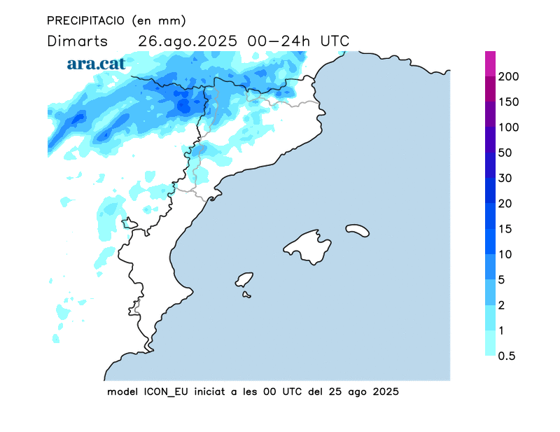
Rainfall recorded throughout Monday:
- Nuria (1,971 m): 8 l/m2
- Ulldeter (2,413 m): 5 l/m2
- Espot (2,519 m): 5 l/m2
- Torredembarra: 2 l/m2
- El Vendrell: 2 l/m2
- Cambriles: 1.5 l/m2
- San Juan Orchard: 1.5 l/m2
- Miami Beach: 1.5 l/m2
- Barcelona (Port): 1.5 l/m2
