Which fires are the Firefighters putting out? The map of Catalonia, fire by fire
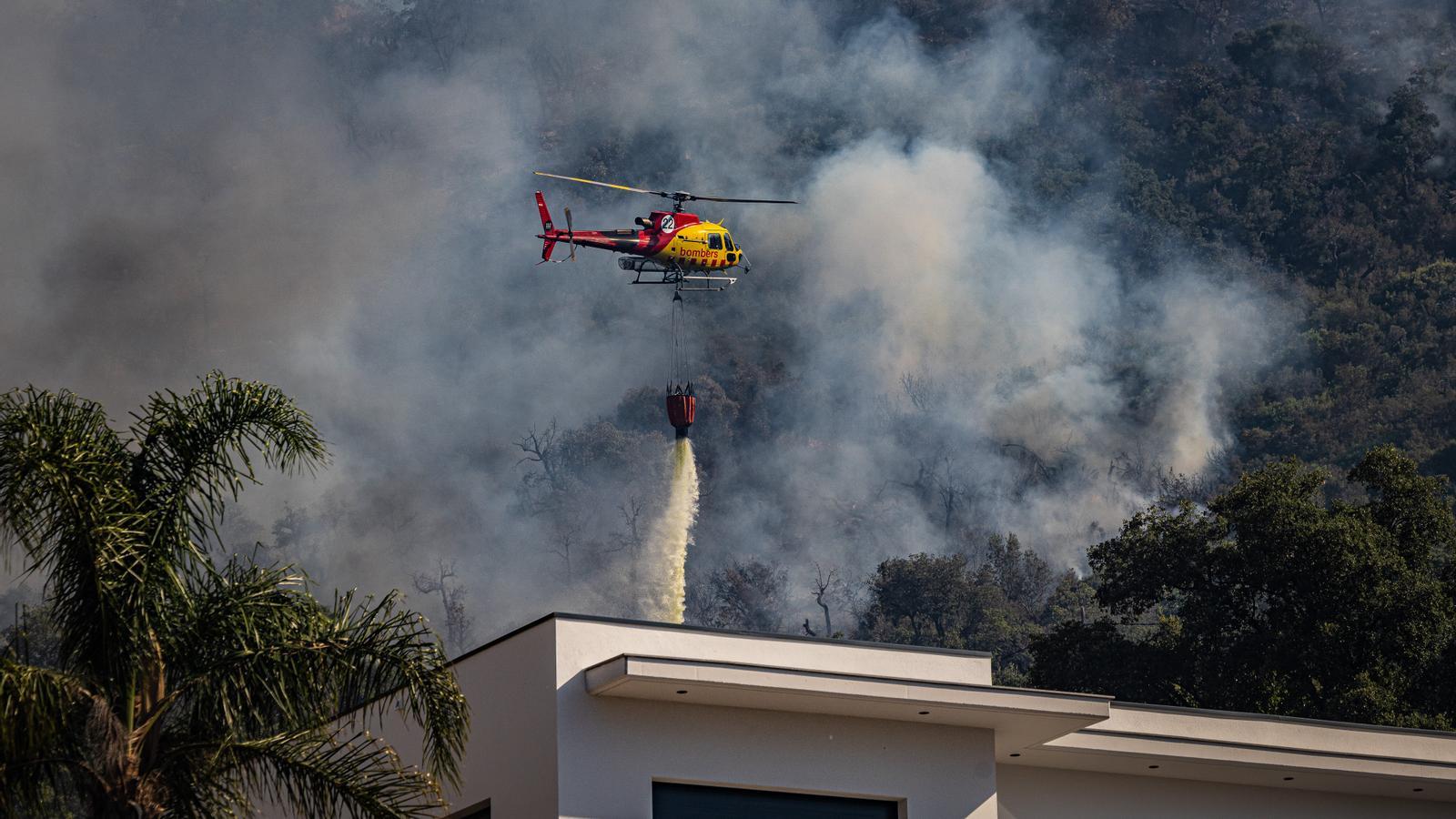
The extinction body is facing an scenario of simultaneity every day, one of the most worrying

BarcelonaCatalonia faces a much better water scenario this summer than in previous years, but this does not mean that the risk of fires is lower. Abundant rains, especially during the winter, have allowed water reserves and the territory's water status to be recovered. Reservoirs have been filled, forests have been recovering from the historic drought, and vegetation has grown strongly after months of generous rainfall.
However, this very growth of vegetation brings a less positive consequence. With the premature arrival of high temperatures and the lack of rain in recent weeks, a large part of the vegetation cover has been rapidly drying out and has become a large amount of fuel available in case of fire. This means that, despite the territory being much less dry than in recent summers, the potential for a fire to gain intensity remains high in many areas, especially inland.
A clear example is the serious forest fire that burned in early July in the area of La Bisbal d'Empordà (Baix Empordà). During its first 48 hours, it advanced uncontrolled, fanned by the reheated tramuntana wind. Many other fires have also occurred throughout the country during the first fortnight of July due to constant heatwaves, although they have not burned anywhere near as many hectares as the one in La Bisbal. After this wave of simultaneous fires, there are currently no major active fires in Catalonia.
With the constant heatwaves we are having this summer, simultaneous fires are occurring practically every day in southwest Europe, the worst-case scenario for firefighters. This July is being devastating in the Iberian Peninsula and France, where the fires are historic. The severe fire that has been burning for days between the Community of Madrid and Ávila has already ravaged more than 55,000 hectares, the worst burnt area in the history of Spain. And near Bordeaux, there is also an out-of-control fire that has already ravaged more than 40,000 hectares. French authorities assure that it will take weeks or months to completely extinguish this fire, the worst in the history of this country. The most tragic fire was that of Los Gallardos, in Almería, which caused the death of 13 people. In Europe as a whole, more than 400,000 hectares of forest have already been burnt this year, half of which in Spain, the state most affected by this wave of fires that gives no respite due to extreme heat and drought.
Active fires
In this map, updated minute by minute by the Bombers de la Generalitat, you can consult all the fires declared in Catalonia depending on their status, be it active, stabilized, controlled, or extinguished. The scenario of simultaneous fires is always one that causes the most distress to the Bombers, as they face the possibility, however distant, of not reaching all fires or not being able to allocate the necessary resources to them. To define the fires in our country, the Bombers speak of generations.
Lately, there has been much talk about sixth-generation fires, which burn at unprecedented speeds, affect large areas, and create large pyrocumulus clouds that generate their own extreme weather conditions. Fifth-generation fires, however, are those that occur simultaneously. On Tuesday, July 7, in the evening, for example, the situation was very critical, as the Bombers had to work on about fifty fires at the same time. Most were small fires, but there were worrying ones, such as those in Sentmenat, Anoia, and la Bisbal d'Empordà.
The danger of fire
In this other daily updated map you can check the fire danger level of your municipality, which is high or very high in many regions. and extreme in some areas, especially in the interior of Tarragona and between the Alt Camp and Penedès. The Rural Agents and Civil Protection keep the accesses to some natural spaces closed due to the extreme risk of fire in these areas. However, the showers and heavy storms that occurred last weekend of July have made it possible to reduce the risk of fires in regions, especially in Barcelona, Girona and the Pyrenees. All this with a refresh that has allowed us to catch our breath before the arrival of the fourth heatwave of the summer.
This summer there is a key factor: extreme heat. Since spring, Catalonia has been experiencing extraordinarily high temperatures for this time of year, with several episodes of intense heat that have culminated in three consecutive heatwaves. In fact, Catalonia has recorded the warmest start to summer since records began, with a record average temperature of 3.8 ºC above the climatic average between June 1 and July 15. High temperatures accelerate the drying of vegetation, reduce environmental humidity, and create more favorable conditions for any ignition to quickly turn into a forest fire.

How many hectares have burned this year?
This year, more than 3,400 hectares of forest have already been burned in Catalonia, the vast majority of which during the Bisbal d'Empordà fire. We have already had almost 500 fires declared, and the region with the most fires declared so far is Vallès Occidental. A figure of burned land that is currently better than, for example, last year, when during the heatwave between the end of June and the beginning of July, a large fire occurred in Ponent that ravaged more than 5,000 hectares of forest and agricultural land.
In fact, last year was the worst of the last decade in terms of burnt area. If we add forest and non-forest land, nearly 10,000 hectares were scorched. In the following graph, you will find the forest hectares burnt each year since 1970, with 1994 being the worst year for burnt area, followed by 1986. The significant investment made for years in Catalonia for fire prevention and extinction is helping to ensure that recent years are far from the catastrophic figures of the eighties and nineties, especially regarding the number of fires.
With global warming and the climate crisis, summers are starting earlier and are increasingly dry and hot in our region. Episodes of intense heat are more frequent and can cause increasingly devastating and fierce fires, due to the extreme weather conditions that are generated. These are known as sixth-generation fires.
The combination of abundant vegetation and persistent, premature heat creates a scenario that requires extreme vigilance. Catalonia is experiencing this summer with more water than in previous years in the reservoirs, but also with more fuel in the forests and a lot of heat. Factors that will mark the evolution of this year's fire campaign.
