This weekend, very attentive to the sky (and the thermometers)
The DANA 'Adam' and the entry of humid maritime winds will cause rains and some downpours

-
CAT -
CAST
BarcelonaWe are at the gates of the announced major change in weather. We have experienced the last hours of calm and heat for the time of year, and this weekend the meteorological situation will take a radical turn. It will be from midday and Saturday afternoon when showers and storms will gain ground from south to north in many regions. And Sunday will be a gray, rainy, and suddenly colder day. The rain may be heavy and, in some cases, accompanied by torrential downpours that leave significant accumulations in a short time. For this reason, Meteocat has activated the alert for intense rain in many regions that may leave more than 40 l/m² in just half an hour or more than 90 l/m² in three hours. The warning is red –danger 5 out of 6– in Vallès Oriental, la Selva, and el Maresme.
Rains and a return to the full autumn atmosphere that will be the result of a combination of factors. The anticyclone will settle in northern Europe and a storm will form in the Mediterranean. All this will open a corridor of winds coming from central Europe and will facilitate the arrival of a pocket of cold air at altitude in the north of the Iberian Peninsula. This is a DANA that has been named Adam, the first on the official list of DANAs and storms for this season. This will reactivate instability and cause thermometers and the snow level to drop.
In addition, humid maritime winds from a sea that remains quite warm will be reinforced, which can fuel the intensity of the precipitation. This is a situation that we will have to follow with great attention, since depending on the final position of all these pieces, the rain will be more or less widespread and intense. Some models maintain the possibility of an easterly storm between Sunday and Monday.

Saturday: rain starting in the afternoon
This Saturday we will still wake up to quite calm conditions, sun and a mild atmosphere, but intervals of clouds will increase as the hours pass. From midday and during the early afternoon hours, showers and storms will appear and gain ground in the Pyrenees, the Pre-Pyrenees and Girona. Throughout the afternoon and evening, the rainfall will extend to the regions of Barcelona, and later in the day to more places, especially the coast and pre-coast of Tarragona.
Rain that can be intense and locally leave some torrential downpours that accumulate a lot of water in a few minutes or hours. In the afternoon they will be more likely in the northeast, and from the evening onwards the main event will move to the coast and pre-coast of Barcelona and nearby areas, such as Central Catalonia. There are many alerts activated, caution above all in flood-prone areas and near rivers and streams that can rise suddenly.
Temperatures will drop throughout the day, and many minimums may be recorded at the last minute. Even so, most maximums will still range between 20°C and 25°C, higher in the Ebro valley and in Ponent. The tramuntana wind will strengthen on the Costa Brava, with an increasingly rough sea state.
Sunday: gray and cold day
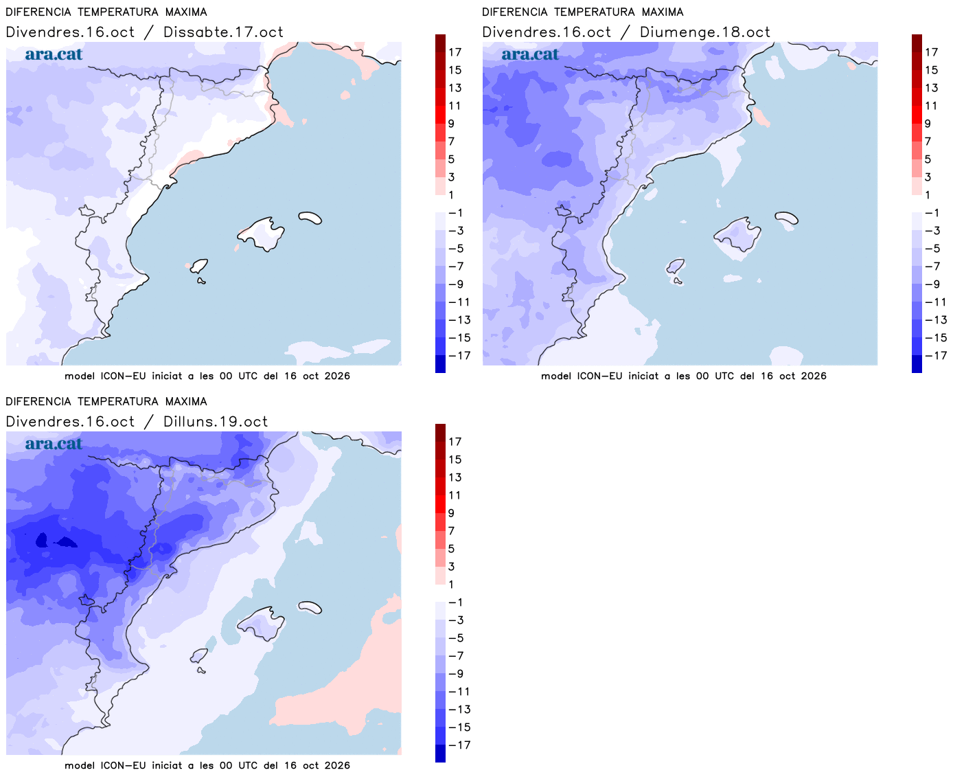
What we will notice most on Sunday will be a sharp drop in temperatures. The atmosphere will be cold in general, with many highs of only 13°C to 17°C, but clearly lower in mountain areas. An atmosphere of advanced autumn suddenly and values below what would be expected at this time of year. The decrease in highs can be in some cases up to 10 degrees compared to days ago.
All this with weather that will continue to be quite unsettled. A gray sky is expected throughout the territory, with a risk of rain anywhere. There is still some uncertainty about the final distribution of the precipitation, a classic in these Mediterranean autumn situations. There will be a risk of some downpours repeating, especially between Tarragona and Barcelona, while towards Ponent, the Costa Brava and the western Pyrenees the rain would be less likely.
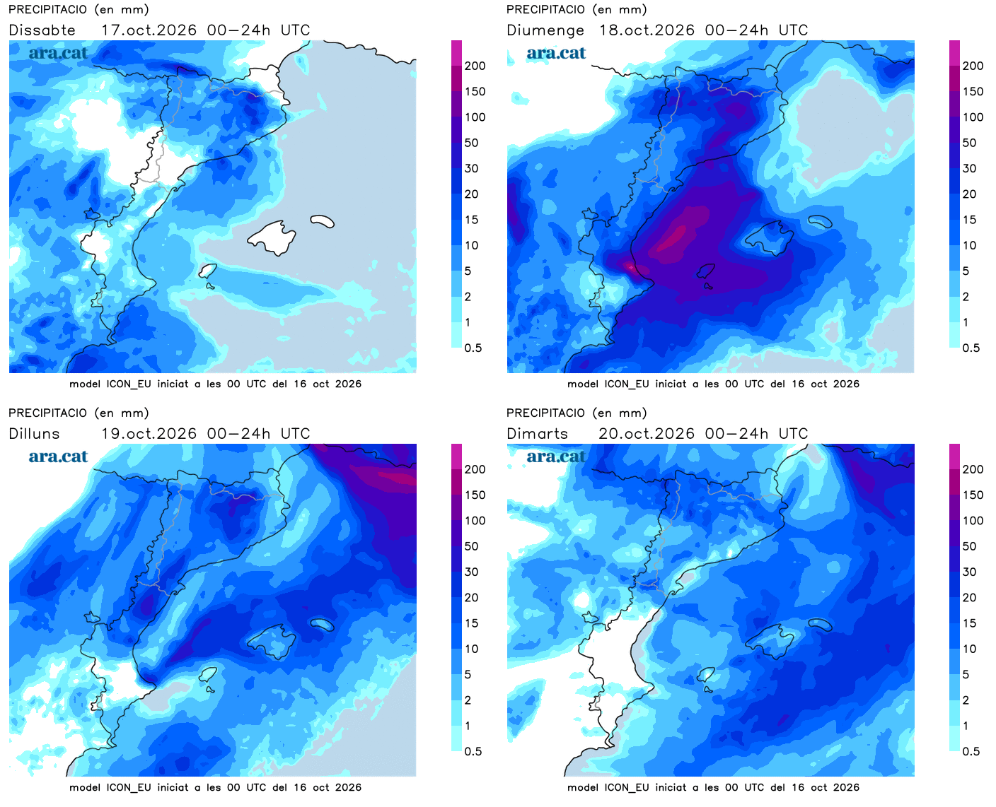
Attention to the Valencian Community and the western half of the Balearic Islands, where rainfall will be heavy and abundant, with a risk of torrential downpours and significant accumulations. There are many alerts activated in this regard. There will be tramontana winds in the Empordà and northeasterly winds along much of the coast, which will accentuate the feeling of cold, with a very rough sea state.
In the Pyrenees, the snow level will drop to 2,000 m or, locally, below. Therefore, the high peaks of the mountain range may be dusted with snow. Next week, the weather will remain unsettled, with a risk of further precipitation and an environment that will continue to be distinctly autumnal.