Temporary return to typical December weather: sun and fog
The fog will be persistent in the Central Depression


We've already weathered a recent surge in rainfall, the icing on the cake of a very wet second half of December across almost the entire country. This has made December the sixth wettest on record at the century-old Fabra Observatory in Barcelona, and the wettest in decades in other parts of the country. However, this Tuesday will mark the end of the rainy period that began almost two weeks ago: it won't rain anywhere, and the sun will take center stage, though with patches of inland fog that will make it difficult for the sun to appear until mid-morning or midday.

Tuesday: foggy inland and sunny elsewhere
More pleasant weather is expected on Tuesday, marked by the return of the sun—good news for everyone who has been waiting a week for it to appear so they can hang out the laundry. However, sunshine will be harder to come by in central Catalonia and the Central Depression, where morning fog will create a cold and damp atmosphere that will gradually dissipate throughout the day. Minimum temperatures have dropped slightly, with more frost expected inland, while maximum temperatures will remain relatively stable and may even rise slightly due to the sunshine. The tramontana and mistral winds will also reappear in both ends of the country, with gusts reaching 70 or 80 km/h.

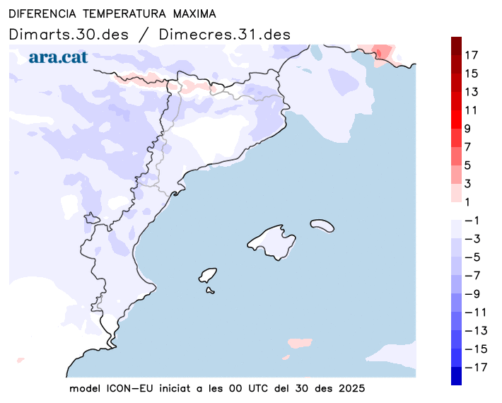
Wednesday: Cold weather and a risk of some showers
The weather will remain fairly stable heading into Wednesday, with fog again in inland areas during the morning and cloud formation along parts of the central coast, which could even bring some isolated showers. The wind will weaken and become less intense on Tuesday in the far reaches of the region, and temperatures will drop slightly, both day and night. This temperature decrease will bring maximum temperatures between 11°C and 14°C along the coast and pre-coastal areas, and between 6°C and 9°C in the rest of the interior, with minimum temperatures well below freezing in the Pyrenean valleys.
Waiting for a possible cold front to accompany the Three Kings
The calm weather that has followed the recent easterly winds could be the prelude to a cold snap arriving from January 5th onwards, bringing noticeably colder temperatures and widespread frosts across the western half of the European continent. Some weather models indicate that this cold front will be accompanied by snow at lower elevations, including in Spain, but this possibility cannot yet be confirmed, both due to the number of days remaining and the complexity of forecasting snow at low elevations in a Mediterranean country, where many factors come into play.

