Severe storm warnings in many areas today: where and when it will rain
The significant change in weather will also bring a clear refreshment, with a late summer atmosphere.

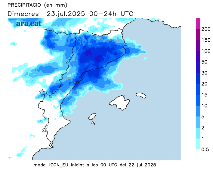
BarcelonaToday we will experience a significant change in the weather due to the arrival of a pocket of cold air that will clash with the heat accumulated on land and at sea. This will cause significant instability and a significant cooling. Showers and thunderstorms will reach many areas, especially in the afternoon. They can be strong and accompanied by downpours, hail, hail, or gales, which is why Meteocat has many regions under warning, and Civil Protection has activated the Inuncat plan alert. Some rainstorms can accumulate locally more than 40 l/m² in just half an hour. This episode will last until dawn and the early hours of Thursday morning, although it will not clear up after that. Temperatures will drop sharply, and in the coming days the atmosphere will be more typical of late summer, with very mild heat and cool nights.


Wednesday: significant change in weather
The arrival of a pocket of cold air will greatly complicate the weather this Wednesday. During the morning, there will be more cloudy periods, and the first scattered showers will fall, especially in the south, in the west, in the Pyrenees, and in the western Pre-Pyrenees or on the southern pre-coastal area. The first intense thunderstorms cannot be ruled out.
Showers and thunderstorms will spread to many areas from midday onwards, throughout the afternoon, evening, night, and early morning. The main event of the event will begin in the Pyrenees, the Pre-Pyrenees, and central Catalonia, and will move throughout the afternoon to all regions of Girona and Barcelona, also reaching the coast. During the evening, new clouds will grow, bringing more showers and thunderstorms to the Camp de Tarragona region and other areas in the center and north of the country.
Some downpours could leave local rainfall of over 40 l/m², but Meteocat has also issued warnings for accumulations of up to 100 l/m² or more in the eastern Pyrenees and Pre-Pyrenees, as well as central Catalonia. A complicated day ahead, so be careful on the roads if you encounter strong storms. However, the rain will be light in the West and inland areas of the Ebro.
Temperatures will drop significantly inland and in the Pyrenees, with the heat remaining at bay. On the coast, the drop will begin in the afternoon, especially in the late afternoon.
Cool and new showers in the coming days
The early hours of Thursday morning will still be unsettled, with heavy showers and thunderstorms, especially in coastal, pre-coastal, and northeastern areas. Thursday afternoon will see repeated showers and thunderstorms in the north of the country, the Balearic Islands, and the southern Valencian Community, and Friday will not be entirely clear. Snow may even be falling on the peaks of the Pyrenees these days, with the snow level slightly below 3,000 m. The weekend looks to be quieter, but with luxurious warmth.
Wednesday night into Thursday will be considerably cooler, and this situation will last for several days. Temperatures will bottom out, with most highs below 30°C or 25°C. From Friday onward, temperatures will rise slightly, but the heat will remain moderate. An atmosphere and stormy weather more typical of late summer than the heatwave, and no warmer weather in sight. Below-average values due to this atypical cooling for the time of year.