Rain and storm watch: where and when it could rain this weekend
Rainfall will be very irregular but locally heavy, with several regions on alert.
BarcelonaThe passage of a cold front reactivated the instability this Friday, right in the middle of the Diada holiday, with 29 l/m² in Montserrat, 20 in Sant Joan de les Abadesses (Ripollès), and 14 in Olot (Garrotxa). Rain has fallen in several regions during the night and early morning, with locally intense showers and thunderstorms in the northern half of the country. Meteocat maintains its warnings for many regions for heavy rain, and Civil Protection has activated the Inuncat Plan alert. On Sunday, calm and sunshine will gain ground, with scattered showers between the Ebro and the Valencian Community. Temperatures will tend to rise, with moderate heat and muggy conditions on the coast.

Saturday: new showers and storms
The first day of the weekend will be marked by great instability. Throughout the day, showers may appear irregularly in many places. With some uncertainty, showers will be more likely in the morning in coastal, pre-coastal, central, and northern areas, while in the afternoon, showers and thunderstorms will become concentrated in the regions of Girona, Barcelona, the Pyrenees, and the Els Ports area. They may be locally strong. The day will feature changeable skies and weather, with periods of abundant cloud cover and fog, especially in mountain areas.
Temperatures will rise, both minimum and maximum, with a cool to mild atmosphere early in the day and moderate heat in the middle of the day. They will only remain similar or drop slightly towards the west. Many highs of 24 to 29°C, higher in the southern inland. The north wind will strengthen in the Empordà region.
In this regard, Meteocat maintains active warnings of intense rainfall affecting a large portion of the northern and eastern regions of the country.
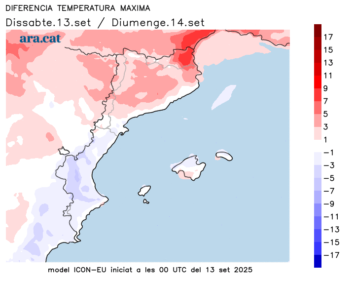
Sunday: calmer
The long weekend and the weekend will end calmly, with sunshine gaining ground, especially in the West and north. There will be some cloudy patches in coastal and pre-coastal areas, while between the Ebro and the regions of Castellón and Valencia, cloud cover will be more abundant, with some scattered, minor showers.
Temperatures will rise further inland and in the Pyrenees, but will remain similar near the sea. On the Ebro, in the Valencian Community, and in the Balearic Islands, maximum temperatures will fall due to increased cloud cover. The weather will be generally warm in the middle of the day.
Calm strength and more heat next week
The anticyclone will gain ground next week, with relatively calm and sunny conditions. However, there will be some instability between Monday and Tuesday, with scattered showers. Temperatures will rise as the days go by, and the second half of the week could be especially warm, with above-average values.
Early morning storm forecast
A series of showers and thunderstorms swept across the northern half of the country for much of the early morning hours, often accompanied by lightning, strong gusts of wind, and hail. The rainfall was torrential in some cases, and a new Catalan record for accumulated precipitation in just one minute was set: 7.6 l/m² at 5:27 a.m. in La Quar (Berguedà). The 26.1 l/m² accumulated in five minutes in the same municipality is also a record, at least since minute-by-minute rainfall began (2009). These are the most notable precipitation records up to the early morning:
- La Quarto: 50 l/m²
- La Bisbal de Empordà: 47 l/m²
- Vic: 45 l/m²
- Girona: 43 l/m²
- Sau Reservoir: 41 l/m²
- Orís: 38 l/m²
- Queralt Sanctuary: 36 l/m²
- La Pobla de Segur: 34 l/m²
- Organic: 30 l/m²
