The heat wave will rekindle in the coming days
Temperatures are set to soar again, and new heat alerts have already been issued.

BarcelonaTemperatures dropped another notch yesterday in the west of the country, where for the first time in quite a few days they fell below 40°C. However, the heat remained intense throughout, with almost 38°C, for example, also in the Girona region and in some parts of the Barcelona pre-coastal area (you'll find the most important data at the end of this report). In the coming days, we'll see another scorching peak. We're experiencing a relative and brief respite from the second heat wave of the summer, but it will flare up again and last at least until next Monday. We expect very hot days, with extreme temperatures clearly above average. Temperatures will again exceed 40°C in the hottest areas, especially starting Friday and into the weekend.
Today there will be showers and thunderstorms in many parts of the northern half of the country, but from Friday onwards, sunshine and calm will prevail with no further precipitation. The maps indicate a clear cool-off will arrive starting mid-next week, and this change in weather could bring the typical round of late-August storms. Until then, we'll have to sweat it out.

Thursday: heat and afternoon showers
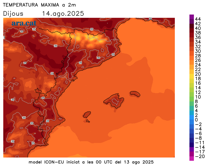
The night has once again been tropical and sleepless in many places, especially along the coast and pre-coast. In fact, some torrid lows—over 25°C—have been recorded repeatedly in some coastal areas, especially on the urban island of Barcelona, where almost 30 torrid nights have already been recorded this year. And highs will already begin to rise further in the southern half and the central coast and pre-coast, especially because the marina will take longer to arrive, which will cause the mercury to rise further in these areas. Therefore, Meteocat has again activated intense heat warnings in many regions between today and Saturday.
As for the weather, the morning will be calm and sunny overall, but the first clouds will already be growing in parts of the Pyrenees and Pre-Pyrenees. From midday and into the afternoon, showers and thunderstorms will occur in these areas, eventually reaching parts of Central Catalonia, Western Catalonia, and even some areas of the pre-coastal region. The storms will be locally strong and may be accompanied by strong winds and hail. Meteocat has issued warnings for heavy rain in some parts of the north of the country.
These storms will cause maximum temperatures to drop further in the Pyrenees, Pre-Pyrenees, and nearby areas, but this will be a temporary drop and not representative of the rest of the country, where it will once again be a very warm day, with many highs of 32 to 38°C. There may also be some afternoon showers in inland areas of Valencia and Mallorca.
New surge in the heat wave
Friday will be even hotter, and temperatures will rise further over the weekend. We're facing a resurgence of the heat wave, and this situation will last at least until next Monday. We're in for another torrid few days, with temperatures well above normal, widespread sleepless nights, and the recurrence of tropical or torrid lows.
The good news is that the maps continue to indicate a clear cooling off period in mid- to late next week, bringing temperatures back to normal and putting an end to so many days of extreme, unbearable heat. No more showers are expected after Thursday, but next week's cooling off period could be accompanied by a more extensive round of showers and thunderstorms. Typical conditions for late August, yet to be confirmed.
Wednesday's heat report
Temperatures didn't soar as high yesterday across the country, and for the first time in quite a few days, no 40°C temperatures were recorded anywhere, not even in the Ebro or Ponent. However, temperatures reached or exceeded 38°C in these areas again, and this figure was also close to reaching it in areas such as the Girona region and the Barcelona pre-coast. It was very warm, but far from the 42 or 43°C seen a few days earlier. And afternoon storms and showers were also rarer, affecting mainly the Alt Pirineu and Els Ports. However, significant local rainfall was observed in the western Pyrenees, with a notable 37 l/m² in Vielha, in the Aran Valley. These are the most notable maximum temperatures recorded yesterday:
- 38.3°C: Vinebre
- 37.9 ºC: Darnius - Boadella Swamp
- 37.8 ºC: Sant Cugat del Vallès - CAR
- 37.7 ºC: San Romano de Abella
- 37.7 ºC: Tempering
- 37.7 ºC: Lleida - la Femosa
- 37.6 ºC: Albesa
- 37.6 ºC: Golmés
- 37.5 ºC: Tàrrega
- 37.4 ºC: Espolla
