Severe storm warning and increasingly less heat this weekend
Temperatures will drop, especially inland, but the cooler weather will also reach the coast, especially starting on Sunday.
BarcelonaStorms will become more prevalent throughout the weekend. The weather will be uncertain, with mornings with relatively clear skies, but unstable and stormy afternoons. The weather has been affected by the instability. This afternoon, it could rain in many places, and storms will be repeated in several areas on Sunday.

Saturday: more storms
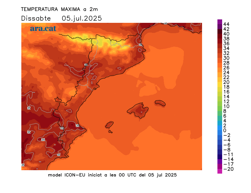
The night was once again heavy and sleepless near the coast, with muggy conditions and tropical lows, as well as some torrid temperatures—above 25°C. Where it cooled off a bit, it was in the Pyrenees, with lows around 12°C in the valleys. Maximum temperatures will drop significantly throughout the interior and in the Pyrenees. Therefore, we will no longer experience extreme heat anywhere, although the warm atmosphere will remain, with many highs of 31°C to 36°C. Furthermore, rain will gain ground in the afternoon, helping to prevent the mercury from skyrocketing. Little change has yet been seen on the coast, with a heavy and muggy atmosphere.
All this with plenty of sunshine and calm in the morning, with the possibility of some scattered showers in the Pyrenees and the West, which will become more widespread as the morning progresses.
Showers and thunderstorms will clearly gain ground from midday onwards and throughout the afternoon and early evening, and they may fall irregularly in many places. They will affect all parts of the interior, the pre-coastal area, the Pyrenees, and the Pre-Pyrenees. They may be accompanied by downpours, hail, hail, and strong winds. The possibility of showers reaching some coastal areas, especially the Costa Brava and the Barcelona coastline, is not ruled out.
Meteocat has issued warnings for heavy rain in many regions. Civil Protection has activated the Inuncat Plan for these possible downpours, especially in Central Catalonia, especially Bages, Moianès, Lluçanès, and Osona, as well as in the Pyrenees, Pre-Pyrenees, Pre-coastal areas, and the Lleida region.

Sunday: instability and moderate heat
The passage of a front will also make the weather more unstable on Sunday. Already in the morning, there will be more changeable skies and a risk of scattered showers in the northeast and the Pyrenees. However, showers and thunderstorms could appear from midday onwards and into the afternoon, especially in the Pyrenees, the Pre-Pyrenees, the Girona region, and the north of Barcelona. It is unclear whether the showers will also reach more coastal and pre-coastal areas, as the weather maps do not agree on this. Calm and sunny conditions will be expected in the south and west.
Rain will help cool the air. In fact, temperatures will drop even further in the northern half of the country. More moderate heat and a less heavy atmosphere will be felt on the coast. Many highs of 28°C to 33°C, lower in mountainous areas and slightly higher in the west and southern inland.
At least two or three days of heat at bay
The drop in temperatures will solidify early next week. We're looking forward to a moderately warm Monday and Tuesday, with many highs of 26°C to 31°C, slightly higher in the south and west.
There will be some lingering showers, but the most notable will be concentrated between the Balearic Islands and Valencia. Starting Wednesday, temperatures will rise again, and the heat will become more intense.
Yesterday afternoon's severe storms affected parts of the Pyrenees, the Pre-Pyrenees, and central Catalonia. In the afternoon, they also reached nearby areas, such as the Barcelona pre-coast. The rainfall was very irregular, but there were real downpours in some cases, leaving significant amounts of water in a short period of time. Of note were the 53 l/m² in Guixers-Valls and 35 in Navès (Solsonès), the 46 in the Sau reservoir (Osona), and the 34 in Molló (Ripollès). Also recorded were 23 l/m² in Pujalt, 14 l/m² in La Seu d'Urgell, and 3.5 l/m² in Terrassa.
- Temperatures temporarily rose sharply again in the northeast and southern interior of the country, with some highs exceeding 38°C. 38.9°C: Torroja del Priorat
- 38.5 °C: Darnius Reservoir - Boadella
- 38.5 °C: Aldover
- 38.4 °C: Vinebre
- 38.3 °C: Cabanes
- 38.2 °C: Espolla
- 38.1 °C: Banyoles
- 38.0 °C: Segre Towers
- 37.8 °C: Vilanova de Segrià
- 37.6 °C: Fornells de la Selva
