Sprinkles to start the weekend
There will be heavy showers and the temperature will return to normal in the coming days.
BarcelonaThe weekend begins with the passage of a cold front that will leave some scattered showers or drops during the early morning and early morning hours. By early morning, around 12 mm had accumulated in Gisclareny, 10 mm in Cardona, and 8 mm in Pinós. Sunshine and calm will prevail over most of the country, but fresh afternoon showers will fall in the north and along the pre-coastal area. These will diminish on Sunday, but could reach more regions by the middle of next week.
Today, temperatures will drop slightly and rise again with intense heat on Sunday. However, temperatures will normalize next week, and we will have much more moderate heat. We still don't see any major heat in sight.

Saturday: some showers until the morning
During the early hours of the morning, a line of instability will finally cross us, leaving some scattered, weak showers and drops from west to east. They may reach many places and will be minor, but it will not rain everywhere. For example, areas such as the Barcelona coast, the Costa Brava, and the interior of the Ebro River are unlikely to receive any rainfall. However, towards the Pyrenees and Pre-Pyrenees, some showers may be more intense and may be accompanied by thunderstorms. In fact, early in the morning there are some thunderstorms in northern Berguedà and Cerdanya, locally strong and with thunderstorms.
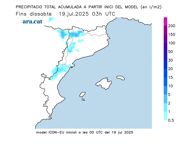
Things will move along quickly, as the weather will be calmer by midday, with the sun dominating most regions, with some cloudy patches. In the afternoon, dark clouds will gather in mountainous areas, bringing renewed downpours and thunderstorms to the Pyrenees, the Pre-Pyrenees, Central Catalonia, the Barcelona pre-coast, and between Montseny and the Transversal Mountains. Locally, the storms will be moderate to strong and may produce hail or stones. Therefore, Meteocat maintains a warning for heavy rain.

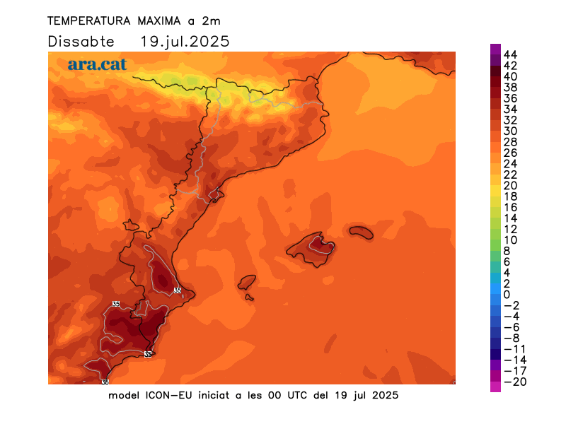
The night has once again been tropical in many places, especially along the coast, where sleep was more difficult, with some torrid lows—above 25°C—in large urban areas along the coast (26°C in Barcelona and 25°C in Viladecans). Highs today will drop inland and in the northern half of the country, where the weather will be more moderate overall. There will be few changes along the coast, with muggy conditions, and a temporary rise in temperatures on the southern coast due to the arrival of superheated mistral winds. In fact, Meteocat has issued a heat alert for this area. Tramontana winds will also be expected in the Empordà region.
Sunday: temporary rebound in heat
Temperatures will rise temporarily on the last day of the weekend. The arrival of a warm westerly wind inland and a garbí wind in the northeast will send temperatures soaring, especially in the Pla de Lleida region and the northern regions of Girona. Many highs of 31 to 36°C are expected, but higher in these areas and in the southern interior. Temperatures will remain unchanged along much of the coast, and even lower along the southern coastline, following Saturday's warm rebound.
Be that as it may, the heat will be fully summery on a typical, fairly quiet day of dog days. The sun will dominate, and in the afternoon, clouds will gather in mountain areas, which, at most, will leave some minor, local showers in the Pyrenees or Els Ports.
Bearable heat next week
We'll start next week under the indirect influence of a deep low in the British Isles, which will send us some cold air aloft. This will cause temperatures to drop further, and throughout the week we'll have normal temperatures for the time of year, or slightly below average. In other words, the heat will be bearable. We're in the dog days, and that means the weather will be warm, but we don't see extremes or major heat waves in sight.
All of this, with new, fairly localized afternoon showers in areas of the Pyrenees and Pre-Pyrenees. The maps indicate that showers and thunderstorms could gain intensity and affect more regions between Wednesday and Thursday. A situation that will need to be confirmed, although it doesn't seem very significant.

New records and data for July
Sea water temperatures broke a new heat record this Friday. Observer Josep Pascual reports that the latest measurement of the sea surface in l'Estartit (Baix Empordà) registered 26.84°C, four degrees above average and the highest value for July in 51 years of data.
Furthermore, on July 5, there was a blast that caused material damage between Sallent and Artés, in Bages. This is confirmed by a report by Meteocat, which also states that on Saturday the 12th, there was a record number of waterspouts in July, specifically six.
The study details that the blast reached a wind speed of 150 km/h in the midst of a strong storm. The event affected a 4.7 km long and 2.5 km wide strip, with hundreds of uprooted or broken trees and damage to roofs and decks. The waterspouts are not typical of July, but the collision between the DANA and the intense heat accumulated on land and at sea created a phenomenon more typical of late summer.
