Sunny and exceptionally warm San Juan
The temperature will rise sharply in Ponent and in the central coast and pre-coast


BarcelonaThe showers on Sunday and Monday afternoon helped cool the atmosphere in many inland regions, but this Tuesday the heat will become even more intense, and the atmosphere will be very warm, truly sweltering in the middle of June. We're entering an intense heat wave that will last two days, although the subsequent "cooling" will be difficult to notice coming from so high up.

San Juan: peak heat in some regions
Both Tuesday and Wednesday will see the African warm air pocket hovering over us, and the heat will be intense, with the possibility of reaching 40°C again in the West, even with occasional dips close to 41°C. Suffocating weather everywhere, with markedly muggy conditions along the coast, tropical nights in many places, and locally torrid lows in some coastal areas. We will likely report the warmest Midsummer's Day in recent years in many regions, especially in the Barcelona and Girona pre-coastal areas, where temperatures could reach 36 or 37°C, including in Barcelona itself.
The Meteorological Service of Catalonia maintains an active warning for intense heat that affects some regions of Ponent (Segrià, Noguera, Urgell, Garrigues, Pallars Jussà and Pla d'Urgell) and the metropolitan area of Barcelona (Barcelonès, Baix Llobregat, Vallès Occidental and Vallès).
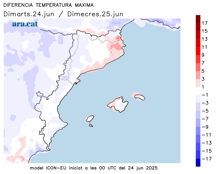
Wednesday: marked temperature rise on the northern coast and pre-coast
Tuesday's highs will be particularly high in Ponent and near Barcelona, but by Wednesday, the heat will be felt throughout the central and northern coast and pre-coast. The maximum temperature will exceed 35°C in inland regions and 31°C or 32°C along the coast itself, with a sea that is practically non-refreshing due to its high temperature. Furthermore, the sun will once again be the star of the show, and no showers are even expected in the Pyrenees.
Balance of the storms of Sunday and Monday
Sunday afternoon and evening storms spread across several areas, where they cooled the sweltering atmosphere and brought downpours and hail or stones locally. Some notable precipitation records included 53 l/m (12.8 US gal/ft).2 of Guardiola de Berguedà, the 44 of Montesquiu or the 42 of Orís (both municipalities in Osona). On Monday, the 56 l/m stand out especially2 Espot (2,519 m, in Pallars Sobirà), 23 m in Puigcerdà (Cerdanya), and 16 m in Tírvia (Pallars Sobirà). Furthermore, on both days, the precipitation was locally accompanied by thunderstorms and hail or stones, causing damage to crop fields.
