Weekend impasse: countdown to the return of the sweltering heat
Some showers will continue to fall, especially until Saturday, with temperatures expected to rise sharply next week.

BarcelonaAfternoon showers and thunderstorms reappeared on Friday, the first day of August, with some strong storms in the eastern Pyrenees and the northeast (you can find the storm data at the end of this report). The weekend will be a tough one. Scattered showers are possible early Saturday morning and in the morning in coastal and pre-coastal areas of the central and northeast regions. In the afternoon, some irregular showers or thunderstorms will repeat in the same areas as on Friday.
From Sunday onwards, and especially in the days following, the weather will be calmer. And beware of the heat, because this weekend it will still be bearable, but next week it will soar and we will return to a fully sweltering atmosphere, especially towards the west. Parts of the Iberian Peninsula will experience a heat wave, but this time Catalonia will be spared, although temperatures will be well above average.

Saturday: some showers
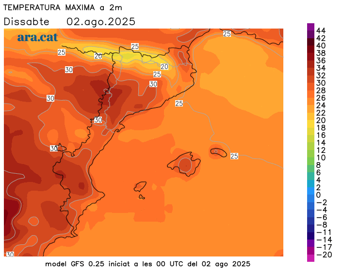
The weather will remain unstable in some regions on Saturday. During the early hours and morning, scattered showers may occur in coastal and pre-coastal areas around Barcelona and in the northeast of the country. However, sunny and calm weather will prevail throughout the day in the southern half and many inland regions.
In the afternoon, cloud cover will gather, leaving new patchy showers in the pre-coastal and inland areas of the Girona region, north of Barcelona, in the eastern Pyrenees and Pre-Pyrenees, and inland areas of Valencia. Once again, some locally intense thunderstorms may occur.
Temperatures will drop in the northeast and rise in the south, with summery warmth far from extremes. Many highs of 25 to 30°C are expected, highest in the West and inland areas of the south. The night will be slightly tropical near the sea, but cool to mild elsewhere. Mistral and tramontana winds at the extremes until early afternoon.
Sunday: calmer
The weather won't clear completely on Sunday, but the risk of rain will be lower. Cloudy patches will continue to appear on the central coast and pre-coastal areas and nearby areas, with some morning showers possible. In the afternoon, new clouds will gather in mountain areas, but will only leave isolated showers in the Pyrenees or Pre-Pyrenees. Temperatures will rise further, with a warm and muggy atmosphere like midsummer, but not extremes.
Intense heat returns.
Next week will be marked by the arrival of a warmer air mass from the south, which will send temperatures soaring. It will be much warmer, with a truly sweltering atmosphere and temperatures as high as 4 or 5 degrees above average, especially starting Tuesday in the West. A few days of high temperatures or occasional highs of 40°C are not ruled out in this area, while temperatures in the rest of the country will not rise as much.
Nights will be heavier and more difficult to sleep in throughout the week, not only on the coast. In addition, the muggy weather will be more intense along the coast and pre-coastal areas.
Friday afternoon storm forecast
This Friday afternoon's storms were locally intense, leaving up to 32 l/m² in Molló, in Ripollès. Also notable were 19 l/m² in Sant Pau de Segúries, 13 l/m² in Banyoles, and 12 l/m² in the Bas Valley. Particularly notable were the rainfall records in the Camprodon Valley, with nearly 100 l/m² in Villalonga de Ter, 92 l/m² in Setcases, 80 l/m² in Tregurà, and 69 l/m² in Camprodon.
