General coolness and some showers during the afternoon
Thunderstorms in the northeast during the second part of the day

BarcelonaAs the disturbance recedes, stability returns, with a very cool atmosphere in these early hours of the day. The weather tends to improve, but it won't clear up completely. The cold air above us will still generate storm clouds, especially during the afternoon in the northeast. Inland and in the Pyrenees, temperatures have dropped the most, with lows around 7°C in the valleys. The muggy nights on the coast are finally behind us, although temperatures are expected to rise again over the weekend. However, temperatures are not expected to be particularly hot.
The stormy season has left rainfall throughout Catalonia, with higher values near the coast (35 l/m² in Viladecans), and between 40 and 50 l/m².2 in some towns in Maresme and the Pyrenees (more details at the end of this information).


Friday with some cloudiness and some showers in the northeast
Today will be calmer. The northern Maresme region and the southern Costa Brava will be partly cloudy with the threat of showers, while the central and southern coasts, as well as inland areas in the Ponent region and towards the south, will be sunny.
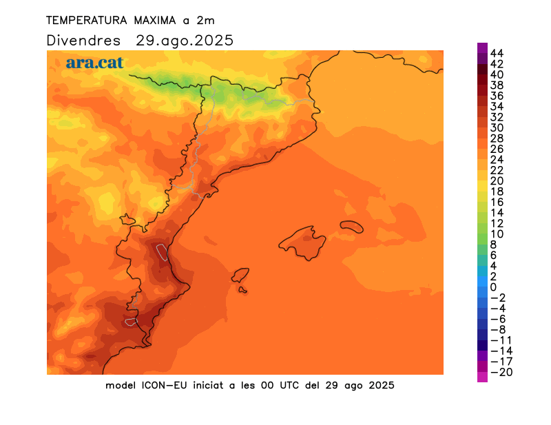
Temperatures dropped this morning, with lows around 19°C on the coast and around 13°C inland. In the Pyrenees, it was very cool, with lows of 7°C in the valleys and 3°C or 4°C at 2,200 metres. Highs today will range between 23°C and 28°C, and will reach 30°C in the Ebro region, the Empordà region, the central pre-coastal region, and the coast, due to westerly and garbí winds, which could warm the air slightly.
The remnants of cold air above us and the approaching tail of an Atlantic front will generate storm clouds in the north, with the occasional re-establishment of storms in the Guilleries-Collsacabra mountains, other points in the northeast, and in Ripollès. They are not ruled out later in the day in Montnegre or Montseny.

Warmer and more serene Saturday
A quiet weekend, especially on Saturday, with a rise in temperature but no significant heat expected. Nights will once again be cool, especially in the Pyrenees, where minimum temperatures will drop to 8 or 9°C (in the valleys). In the high mountains, the temperature will recover slightly, but temperatures will still be more typical of early autumn (at 2,200 m, they will drop to 5°C). On the coast, the thermometer will hover around 20°C, but without any muggy conditions (rest will be possible during the night). Maximum temperatures will remain in check, a few degrees below what would be expected at this time of year. In the Empordà, the Ponent region, and the Ebro, temperatures will not exceed 31°C, and on the coast, temperatures could reach 28°C. Looking ahead to Sunday, after a morning of high clouds, showers and some new storms will return, especially in the Ponent region and the western Pyrenees.
Accumulated rainfall between Wednesday and Friday (in l/m)2):
- Espot (2,519 m): 48
- I live in Llevata: 42
- Luck: 42
- Ulldeter (2,419 m): 39
- Viladecans: 35
- The Pont de Suert: 38
- La Seu d'Urgell: 35
- Raimat: 27
- Gisclareny: 30
- Glass: 27
- Trivia: 27
- San Lorenzo Savall: 21
- Viladrau: 21
- Vallirana: 17
- Barcelona (Port): 14
- Olot: 12
- Sant Martí de Riucorb: 13
- El Prat de Llobregat: 11
