Change in weather today: showers return to some areas
The passage of a front will increase instability, with showers and some intense storms in some areas of the country.

BarcelonaThe calm of the last few hours will not continue today, with the arrival of a cold front that will reactivate instability. Cloud cover will increase, and showers will reappear in some regions, even with some locally intense thunderstorms. Minimum temperatures have risen and the atmosphere is milder this morning, but the change in weather will mean a drop in temperatures in the north of the country this Thursday, which will spread to the rest of the country on Friday. This follows yesterday's peak of warmth, which raised the mercury to highs of 30 to 34°C in many areas of the pre-coastal and inland areas, especially in the northeast, in the Ponent region, and inland from the Ebro. In fact, the drop in the next few hours will be temporary, as the intense heat will rebound over the weekend.

Thursday: change in weather
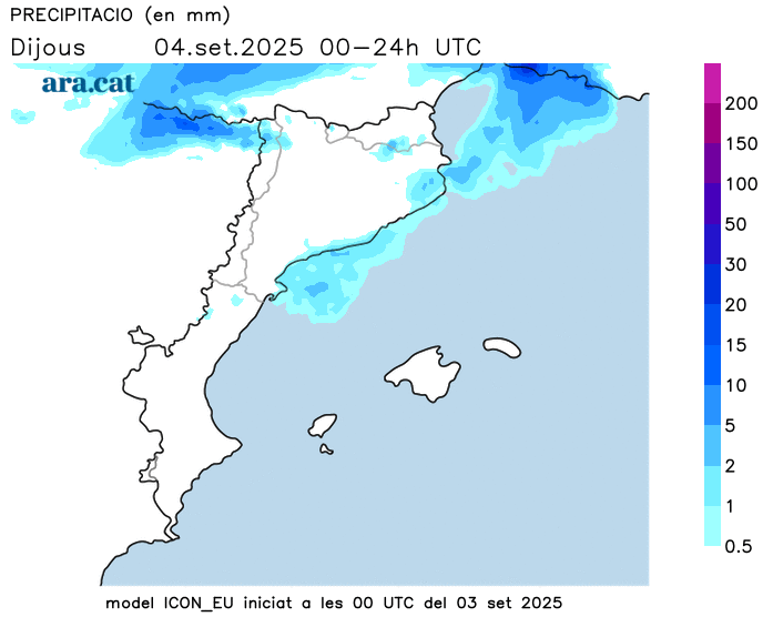
The passage of the tail of an Atlantic front will cause changes in the weather this Thursday. In the morning, there will be more cloudy spells in general, and before midday, the first drops may escape between Central Catalonia and coastal and pre-coastal areas. These will be few, as they will be isolated phenomena. It will be during the afternoon when instability will increase and prominent clouds will grow.
Very irregular showers are expected in parts of the Pyrenees and Pre-Pyrenees, in the northeast, in the Els Ports area, and between Central Catalonia and the pre-coastal area. These showers will be scattered, but locally, some storms could be intense. Rain will be rare in the rest of the country, and the sun will even predominate in the west. Showers may gain ground along the coast from tonight onwards.
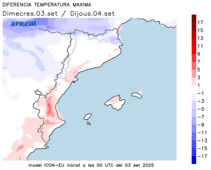
All this with minimum temperatures that have clearly risen, especially due to the presence of more cloudy patches. Less cool in the morning, tropical lows have even increased near the sea and in the south of the country. Maximum temperatures will be similar to most of the country, with a generally warm atmosphere. The exception will be the Pyrenees and the northern Girona region, where the mercury will already be retreating after Wednesday's warm peak. Many values of 27 to 32 °C are expected overall, with muggy conditions on the coast, and a return to 33 or 34 °C is not ruled out in the West and inland areas of the south.
Brief drop in temperatures
On Friday, showers and thunderstorms will continue to fall, potentially locally strong in the early morning hours, but they will remain concentrated between the Ebro and Castellón. Showers will also reach more areas of the Valencian Community throughout the day. However, in Catalonia, the sun will gradually gain ground, with northerly winds in the Empordà. A change in air masses will temporarily drop temperatures.
However, the drop will be brief, because over the weekend, the arrival of southerly winds will cause temperatures to rise again, with intense, summery heat. It seems that next week will begin with a new change in the weather that could bring more precipitation and drop temperatures again. A situation that is still somewhat uncertain, but we will have to confirm it.