Red alert (the highest) activated due to the heat wave this weekend
The heat will be extreme everywhere, and Meteocat warns that temperatures could reach 44°C locally in the southern interior.


BarcelonaMeteocat has activated a red alert—the highest level—for intense heat for Sunday in virtually all regions of Tarragona and the Alt Empordà region, where temperatures will exceed 40°C in many cases and, occasionally, may reach 44°C, especially in the interior of the Terres de l'Ebre region. The rest of the country is also on yellow or orange alert for a generally stifling atmosphere. Temperatures will rise gradually each day and peak on the last day of the weekend, with a progressive increase and expansion of heat alerts across the country. This is a new extreme peak in this long, second heat wave of the summer that will last until next Monday, although the temperature will already begin to drop. Civil Protection has activated the Procicat plan alert for this episode, and throughout today, the forest fire danger level will be determined for the coming days, as dry winds will also blow on Sunday, significantly lowering humidity. Caution is needed this long weekend in August, when many people are on vacation and there are major festivals taking place abroad.
The good news is that this will be the last peak of this extraordinary and prolonged extreme weather event, as temperatures will cool off and return to a clear normal by mid-week. Until then, we'll have to sweat profusely, with sleepless nights in many regions and significantly above-average temperatures. The afternoon showers and thunderstorms of recent days in parts of the north and inland will not be repeated in the coming days.

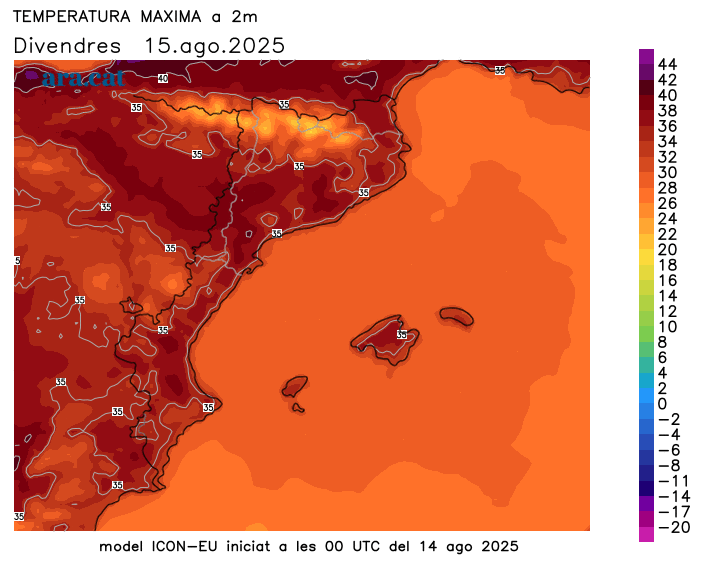
Friday: stifling heat
This Friday, the feast of Our Lady of August, will be a very warm day, with temperatures generally rising. The night has once again been heavy and sleepless, with tropical temperatures on the coast, pre-coast, and some inland areas. Repeatedly, some torrid lows have occurred along coastal stretches, primarily in the city of Barcelona. Many highs will range between 33°C and 38°C, with heavy muggy conditions along the coast, but towards the West and the Ebro Valley, temperatures could reach or exceed 40°C. They could also exceed 38°C in pre-coast areas around Barcelona and Girona. Meteocat has issued intense heat alerts for the entire coast and pre-coast, in Terres de l'Ebre, and much of the West regions for today.
A sweltering day that will be accompanied by sunshine and calm throughout. The showers and thunderstorms in the north of the country will subside in the afternoon, although some completely harmless clouds may develop in mountainous areas. A suspended pulse from North Africa will also continue to be present.
Extremely hot weekend
Saturday will be even hotter, and Sunday will see the peak of this new torrid episode. Most highs will range between 35°C and 40°C in the pre-coastal and inland areas, and between 31°C and 36°C on the coast, with very muggy conditions. In Ponent and inland Ebro, temperatures could again exceed 42°C or 43°C, and even occasionally reach 44°C. In the Tremp basin, the western Pre-Pyrenees, and the Alt Empordà, temperatures could also reach or exceed 40°C. Meteocat extends intense heat alerts across the country, with a red warning in much of the Tarragona region and the Alt Empordà region.
Nights will be very difficult to sleep in and tropical temperatures will be felt in many regions, especially near the sea, where some torrid lows will be recorded. Meteocat has also issued nighttime heat alerts for the Barcelona coast and the Costa Brava. Sunny and calm conditions will remain throughout the weekend. Only a few thin decorative clouds may appear, as well as isolated afternoon clouds in mountain areas, but with no showers.
Waiting for next week's refreshment
Monday will be very hot everywhere, with temperatures likely to reach or exceed 40°C in the warmest areas of the country. But starting Tuesday, temperatures will begin to drop more noticeably, and throughout the week we will gradually notice more bearable warmth. The cooling off will come especially from midweek, with temperatures even tending to normalize after being about eight degrees above average.
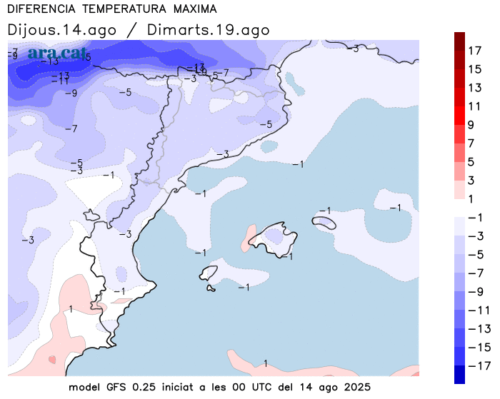
All of this could be accompanied by increased instability due to the arrival of cold air from above. Some maps indicate we could experience the classic round of showers and thunderstorms seen in late August, a situation that is still uncertain and will need to be confirmed.
Thursday's intense heat report
Temperatures already rose somewhat further yesterday, Thursday, especially on the coast and pre-coastline and in the south of the country. They reached over 38°C in the pre-coastline of Girona and Barcelona, exceptional levels in these areas. And they already touched 40°C inland from the Ebro. However, afternoon showers and thunderstorms kept the heat down without major excesses in the north of the country. Of note were the 24 l/m² accumulated in Guardiola de Berguedà and the 22 in Sant Romà d'Abella (Pallars Jussà). Some showers also fell between inland Tarragona and Anoia. These are the highest maximum temperatures recorded yesterday:
- 39.9°C: Vinebre
- 39.2 °C: Torroja del Priorat
- 39.0 °C: Aldover
- 38.7 °C: Darnius Reservoir - Boadella
- 38.7 °C: Seròs
- 38.5 °C: El Masroig
- 38.4 °C: Castellbisbal
- 38.3 °C: Vallirana
- 38.3 °C: Fornells de la Selva
- 38.3 °C: Ribarroja Reservoir
