A more enjoyable weekend, and no trace of the scorching heat.
Temperatures will rise with a warmer environment, but far from extremes and nights that will continue to be cool.
BarcelonaThe weather didn't clear up, and showers and thunderstorms returned in some areas on Friday afternoon, especially in the Maresme region, the Vallès Oriental region, and northern Barcelonès region. These downpours left over 30 l/m² locally in a short period of time, along with some hail, sleet, and strong winds (you'll find all the details and images at the end of this report). In fact, showers were repeated during the night, although the bulk of the precipitation moved out to sea.
All of this has been the prelude to a weekend that will be very calm and enjoyable. There will be no rain on Saturday, and on Sunday only a few scattered showers will reappear in the north of the country. Temperatures will rise further with warmer middays, but still at bay and far from extremes. Minimums will rise after bottoming out on Friday, but nights will remain cool and generally allow for good sleep. The atmosphere will be mild, and there is no heat wave in sight.
Saturday: A day to make the most of
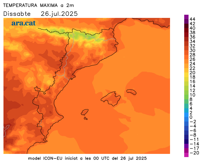
The night was once again very cool for the season, even cold in mountain areas. Lows were mostly below 20°C on the coast, between 13°C and 16°C inland, and again below 10°C in many parts of the Pyrenees, especially at higher altitudes. Highs will rise further, and the atmosphere will be generally warm in the middle of the day, but with temperatures in check and far from extremes. Many values ranged from 24°C to 29°C, and between 30°C and 33°C in the west and southern inland.

All this with very stable weather. The sun will dominate, and no rain is expected. However, in the morning, there will be traces of cloudy periods in parts of the coast and central pre-coast, inland northeast, and on the northern side of the Pyrenees, with the occasional scattered shower possible. In the afternoon, cloudy skies will gather in mountainous areas, with little chance of precipitation. There will be traces of showers in northern Mallorca and Menorca, a mistral wind in the morning across the Ebro, and a northerly wind throughout the day in the northern Empordà.
Sunday: small changes
The last day of the weekend will once again be fairly calm and sunny, but in the afternoon, the clouds will gather a little more forcefully in mountainous areas, leaving some scattered showers. They may fall in parts of the Pyrenees and the northeast interior. Initially, these will be minor and localized. Temperatures will rise slightly, both minimum and maximum, but will remain slightly below average.
The intense heat will continue on vacation
Next week, the heat will remain very moderate. Temperatures will even drop slightly again on Monday. Therefore, we will end July with a very bearable atmosphere, more reminiscent of late summer than the heatwave, with nights that will continue to offer good sleep. The weather will be fairly calm, but with nuances. There will be repeated afternoon showers in the north of the country, but no significant rain is in sight. The weather maps do not predict any heat waves in the medium term, nor in early August.
Friday's storm report
The weather was not clear this Friday, and new showers and thunderstorms formed in the afternoon. This time, they mainly affected coastal and pre-coastal areas north of Barcelona and south of Girona, as well as other areas inland in the northeast. In some cases, real downpours fell, releasing a lot of water in a short period of time, accompanied by strong gusts of wind, hail, and hail. For example, in the Port of Barcelona, wind gusts reached almost 100 km/h. These are some of the most notable records and images from this new afternoon of storms:
- 48 l/m²: Vallromanes and Alella
- 43 l/m²: El Masnou
- 38 l/m²: Cardedeu
- 35 l/m²: Cabrils
- 34 l/m²: Badalona
- 25 l/m²: The Rock of Vallés
- 20 l/m²: Arenys de Mar
- 21 l/m²: Barcelona (Bon Pastor)
- 15 l/m²: Caldes de Montbui
