The historic drought in Catalonia: how the critical situation of the reservoirs was reversed
This year's extraordinary spring rains put an end to a critical episode marked by water restrictions and vegetation loss.

BarcelonaCatalonia has finally left behind the historic drought that has dragged on for more than three years, a dry period that has been exceptional and unprecedented since records began. Reservoirs in the inland basins finally exceeded 80% capacity thanks to the extraordinary rainfall this spring, especially in March. But the recovery of these reserves has not kept pace with the recovery of the accumulated water deficit in forests and aquifers, which, according to experts, will hardly be able to reverse before the next drought hits. In fact, it is estimated that 28% of the trees in Catalan forests died during this long and agonizing drought, losses that cannot be recovered.
Global warming and the climate crisis will cause increasingly longer and more extreme droughts in our country in the coming decades, making our climate more arid and semi-desert-like. Therefore, it is very important to continue promoting water regeneration and desalination, measures that during these critical years have guaranteed 50% of the water consumed in the country. Below, we review the key data to understand the severity of the latest drought and the sudden recovery of water reserves.
Extraordinary rain and snow at last
The month of March of that year was exceptionally rainy, with frequent, widespread, and abundant rainfall that pushed reservoir levels to levels not seen in a long time. Two episodes were key to understanding this rise and finally put an end to the historic drought of more than three years in our country. The first occurred between Thursday, March 6, and Sunday, March 9, with a strong easterly wind and, above all, the passage of an active front associated with the storm. Jana which left more than 100 l/m² and 150 l/m² in some cases. And the second was the Levante wind on March 18 and 19, which left between 40 l/m² and 70 l/m² in the pre-coastal and northeast parts of the country, but locally up to 100 l/m² or more in the Montseny area. Up to four very active storms brought water to our house consecutively during that month, making this the wettest March of the century so far.
And throughout the spring it rained irregularly, with showers and storms here and there. Some of the areas most affected by these rains or snowfalls—depending on the elevation—were the main headwaters of the inland basins, where more than 300 l/m² accumulated in March alone. In some parts of the country, these figures were far exceeded, such as Els Ports, with more than 500 l/m² between March 1 and 31, or some corners of the Montseny area, such as Santa Fe del Montseny, with more than 600 l/m² in the same period, or Arbúcies (Selva).
Water poured into the main rivers, which greatly increased their flows during the spring, causing reservoirs to reach or slightly exceed 80% between May and the first half of June. In March alone, the increase in reserves was nearly 50 points, a scenario unthinkable at the beginning of the year. Such a sudden increase had not been seen since the storm. Glory, more than five years ago. It's also worth noting the heavy snowfall across the Pyrenees, with more than 1.5 to 2 meters of accumulated snow at high altitudes. This allowed, regardless of the rainfall, reserves to steadily increase throughout the spring thanks to the melting of this large amount of snow that hadn't been seen for years.

It had been almost four years—since July 2021—that reservoirs had not reached the levels seen in the spring of 2025. Ultimately, March was a turning point that led to the lifting of restrictions for this drought—the worst on record—which is finally over. However, responsible water consumption must continue beyond improving reserves, as the climate crisis will bring more and worse dry spells like this one.
Reservoir data until the end of the drought
The various episodes of rain in March, melting snow, and showers throughout the rest of the spring caused the reservoirs in the inland basins to fall from 32% at the beginning of March to 81% during the first half of June, the highest level since July 2021. It should be remembered that in 2020, the reservoirs were 37.1% full, and in mid-October, they had dropped again before the DANA, to 27.26%. The historic low of that long and extraordinary drought occurred in early March 2024, with a worrying figure of 14.41%, a level never reached since records began. Therefore, the situation changed radically in just over a year, going from one extreme to the other. We were finally able to face a summer with guarantees, since the summer season is when most water is consumed in our country, which causes reserves to dwindle.
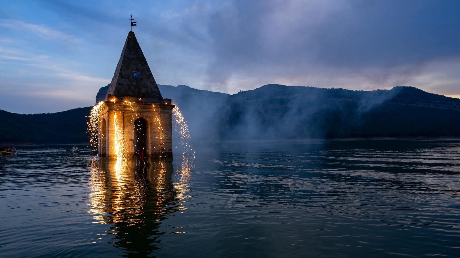
If we look specifically at the evolution of each reservoir, the spectacular rise of Sau stands out, going from being practically empty in February (6%) to over 75% after the abundant rains. It subsequently dropped as water was released to the Susqueda reservoir, which reached around 90%. All of this meant that the emblematic church of Sant Romà de Sau—an icon and thermometer of the drought in our home—went from being completely out of the water to having only the roof of the bell tower exposed. An image of a lot of water that hadn't been seen for a long time. And the Darnius-Boadella reservoir also shot up like it hadn't for some time: it went from 17% before the rains to over 75%. Remember that at the beginning of March, some municipalities in Alt Empordà were still under emergency conditions.
As for the Baells reservoir, it was in an excellent condition unthinkable in 2024, reaching maximum capacity and even releasing water. The small Foix reservoir also reached its maximum, and the Llosa del Cavall reservoir exceeded 80%, while the Sant Ponç reservoir also reached almost full capacity. Since the historic DANA (Dangerous Watershed), the reservoirs in the south of the country have also been improving, and the March rains have boosted them again, although not as much as the others. The Riudecanyes reservoir was at 1.6% before the DANA (Dangerous Watershed), and between May and early June it exceeded 61%. And the Siurana reservoir, which was empty, reached over 26%. This is great news for the areas hardest hit by the drought. Also noteworthy are the large Rialb and Oliana reservoirs, which were filled in spring and had never before had so much reserve water, although they belong to the Ebro Hydrographic Confederation. The Rialb reservoir had to open its floodgates.

Here's a link to access data by reservoir, in this case also those in the Ebro basin, which reached higher levels of almost 90%.
One-year evolution of reservoir recovery
This extraordinarily rainy March came after a winter in which, although some heavy rainfall fell in the northeast and in the Pyrenees and Pre-Pyrenees of Lleida, especially in February, the country as a whole saw little and dry weather, including in the main headwaters of the inland basins. This left reservoirs at 31% capacity in February, a cumulative decline of four points for more than two months. Despite these figures, it's worth noting that these are double the reserves compared to the end of winter 2024; therefore, the situation had clearly improved year-on-year.
Before that, autumn concluded with the wettest October in Catalonia since 2018, and the icing on the cake was the historic and tragic DANA (Dana), which brought downpours and heavy rainfall until early November, especially in the south of the country. Rainfall did not fall equally across the country, as it was more moderate in the headwaters of the main Pyrenean rivers in the inland basins. However, the rain fell heavily in the southern regions, where records of between 100 l/m2 and 400 l/m2 were achieved. This boosted the reservoirs in the area.
The round of rain before the DANA was also generous, leaving close to 100 l/m2 in some parts of the Pre-Pyrenees, while in the main rivers in the north of the country, from the headwaters to the reservoirs, the amounts ranged between 50 l/m2 and 8. This very welcome rain increased river flows and significantly increased some very stagnant reserves for the first time since summer. During September, rainfall had not been very generous in the inland basins and had been concentrated rather in the west of the country, benefiting especially the rivers and reservoirs of the Ebro Hydrographic Confederation (CHE).
All this, in a 2024 marked by a summer that ended with a drop of almost 8 percentage points in water reserves in the inland basins, after the peak of 37.1% and 255 hm³ reached at the end of June (much more than double that of early March). At that time, it was the best figure since early October 2022. September was a fairly rainy month in several regions and with a clearly autumnal atmosphere suddenly, but the rain did not fall equally everywhere and avoided the main inland basins.
Everything started to improve in the spring of 2024, when the tap was finally turned on and rain and snow continued to fall where it was most needed, filling most of the reservoirs. It was the beginning of the improvement in a drought that had just bottomed out in early March. Over those three spring months, more than 400 l/m² accumulated in some headwaters of the Ter-Llobregat system and more than 300 l/m² in the Darnius-Boadella basin. Between 500 l/m² and 750 l/m² accumulated in the headwaters of the Ebro basin, while water was more sparse in the south of the country. Thus, spring did indeed become spring, and the icing on the cake was the widespread rainstorm on Monday, April 29, the wettest day in all of Catalonia at that time since November 23, 2021. The problem is that three years of drought had left a significant mark, and that water was insufficient.
The strong storms and rains of that spring particularly benefited the Ter-Llobregat system, which exploded. Even in mid-June, the water from Sau surrounded and temporarily flooded the emblematic church of Sant Romà de Sau, something that hadn't been seen for a long time. But the water didn't rise as much as it did in March 2025, not by a long shot.
The definitive end of the drought
This graph shows the evolution of the drought over the past five years. It superimposes daily data on reservoir levels in Catalonia's inland basins and daily rainfall, setting the wettest day of the storm at 100. GloryAs can be seen, after the sharp decline of recent years, the situation clearly improved between spring 2024 and spring 2025.
2023 was the worst year of the three droughts. According to ARA calculations based on data from 140 Meteocat stations and taking the 2009-2020 period as a reference, 2023 closed with a 31% precipitation deficit in Catalonia, a figure much higher than the 21% in 2022 and the official 21% from Meteocat, which makes the calculation with a different number of stations and using a much longer reference period.
By mid-November of that fateful 2023, reserves in the inland basins had already dropped even below the lowest level of 1989, the historical minimum recorded until then. It should be remembered that current resources such as desalination plants and reclaimed water did not exist during the 1980s, which shows that the severity of this drought is unprecedented. A scenario that, fortunately, we can already see in the distance.

9 mesos
1 any
Humitat excepcional
Humitat extrema
Humitat forta
Humitat
Normalitat
Sequera
Sequera forta
2 anys
Sequera extrema
Sequera excepcional
Humitat excepcional
9 mesos
Humitat extrema
Humitat forta
Humitat
Normalitat
1 any
Sequera
Sequera forta
Sequera extrema
2 anys
Sequera excepcional
9 mesos
1 any
2 anys
Humitat excepcional
9 mesos
Humitat extrema
Humitat forta
Humitat
Normalitat
1 any
Sequera
Sequera forta
Sequera extrema
2 anys
Sequera excepcional
9 mesos
1 any
2 anys
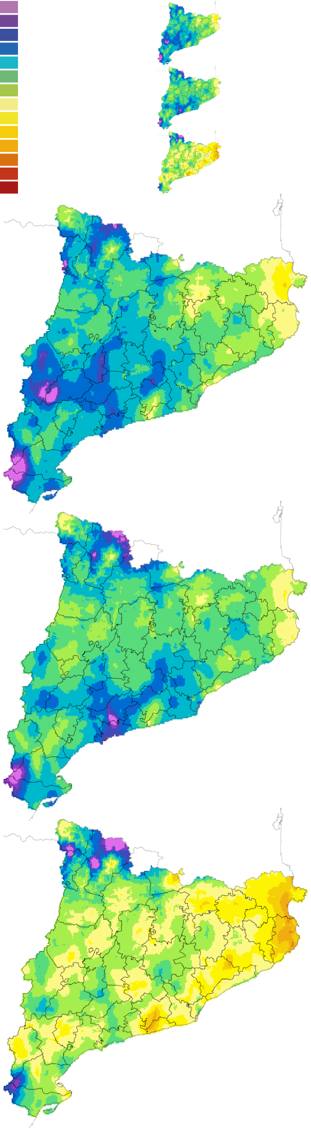
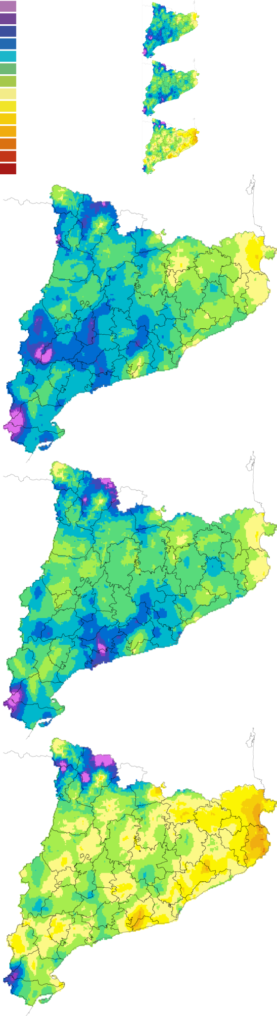
The Standard Precipitation Index (SPI) maps produced monthly by the Catalan Meteorological Service indicate, by region, whether it has rained more or less than expected from that date and going back nine months, one year, or two years. They provide a long-term view of the rainfall drought by region. As can be seen, the situation clearly improved in the spring of 2025. All this indicates that the drought has finally ended after more than three years of rainfall.
