Very cool morning but warmer midday, with unclean weather: it could rain again today.
During the afternoon and evening on Friday, some showers will be repeated, which may be locally intense.

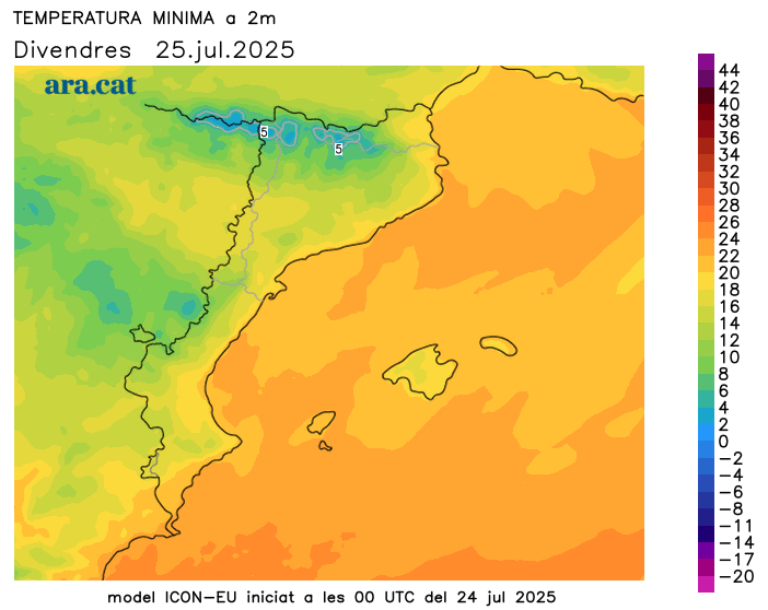
BarcelonaThis Friday begins with a generally cool atmosphere and cold in mountain areas, where a jacket is essential early in the morning. Minimum temperatures have bottomed out, dropping below 20°C on the coast, 15°C inland, and below 10°C in the Pyrenees, including in the valleys. Some Pyrenean peaks even touched 0°C. A coolness more typical of late summer or early autumn than the height of the summer heat, with some record-breaking temperatures even setting yesterday, Thursday (you'll find all the rainfall and coolness data at the end of this report).
Starting today, highs will gradually rise, but still with very moderate heat. After two busy days, calm prevails this morning with plenty of sunshine in most regions, but the instability will not disappear. Between the afternoon and evening, scattered but locally intense storms will occur in parts of the Girona, Barcelona, and Pyrenees regions. In any case, they are nothing compared to the strong and widespread storms that occurred between Wednesday and Thursday (you'll find the full report on the storm data and images at the end of this report). The weekend will be enjoyable, with pleasant nights and a warmer day, but not extreme.

Friday: some showers remaining
The night was very cool throughout and cold in mountainous areas and inland northern Spain. A sweater is necessary early in the morning in many regions, but even a jacket is necessary in these colder areas. It was clearly the coolest night so far this summer. Highs will already begin to rise compared to yesterday and will mostly hover between 23 and 28°C, but reach 30°C in the West and the interior of the Ebro. In any case, the heat is very much in check and unusual for the height of the dog days, with below-average values.
As for the sky, the weather will not be clear. The morning will be generally calm and sunny, although there will be cloudy patches in places, especially in the northeast, and especially on the north face of the Pyrenees, where a few scattered drops and light showers may escape. Mistral and tramontana winds will blow in the Empordà and Ebro regions until midday, and in the afternoon they will be concentrated only in the north of the Alt Empordà region.
From midday and throughout the afternoon, clouds will gather in mountain areas, leaving some scattered showers in the Pyrenees, the Pre-Pyrenees, and the northeast interior. Between the afternoon and evening, these showers will gain strength and may be accompanied by thunderstorms, irregularly affecting areas in the north of Central Catalonia, the coast and the pre-coastline around Barcelona, and southern Girona. Meteocat has some regions on alert for heavy rain. Despite these precipitations, the sun will shine in many regions, especially in the south and Ponent.
Showers will also linger between the Balearic Islands and southern Valencia during the morning and midday, with some strong storms locally. However, they will gradually subside throughout the afternoon, and calm will return. This follows accumulations of more than 100 l/m² in the last few hours between the southern regions of Valencia and northern Alicante. The torrential intensity of the rain is particularly noticeable in the municipality of Pilar de la Horadada, in the Vega Baja region, where 60 l/m² fell in just twenty minutes.
A quieter weekend
The weather will stabilize heading into the weekend. Sunshine and calm will prevail, with only a few low clouds and morning fog and afternoon clouds in mountain areas. At most, the occasional shower or scattered rain shower will occur in the Pyrenees or around Montseny. Afternoon showers are more likely in these areas on Sunday. Temperatures will rise and the weather will be warmer, especially on Sunday, but with moderate heat due to the weather and rather cool nights. Only towards the west and inland areas of the south could temperatures reach 35°C on Sunday. No warmer weather is in sight.
Balance of storms and refreshment
On Thursday, unstable conditions continued in many regions. There were showers and storms at sea that brushed the coast. They mainly affected parts of the Ebro and the Barcelona coast, where rainfall accumulated throughout the day in some cases over 5 or 10 l/m². Showers also recurred between the evening and early night in the Pyrenees, Pre-Pyrenees, and nearby areas. Of note were the 21 l/m² accumulated in Guardiola de Berguedà and the 16 in Guixers-Valls (Solsonès). This rainfall added to the fall since Wednesday. Above all, we noted a significant cooling, unusual for the time of year, even with some record highs. For example, the Meteocat station in San Pedro de Ribes (Garraf) recorded a high of 21.3°C, the lowest for a July in 26 years of records. And the Fabra Observatory in Barcelona hasn't experienced such a cool July day since 2011.
But the main rain event was the episode of showers and thunderstorms that affected many regions between Wednesday and early Thursday morning. The rain swept through many areas from west to east, especially during the night and early morning. In some cases, real downpours fell, leaving a lot of water in a short period of time, as well as numerous hailstorms. Of particular note, for example, were Caldes de Montbui (Vallès Oriental) and other regions, such as Pallars Jussà, with hailstones between two and five centimeters in some cases.
There were many records of 20 to 50 l/m² throughout the episode, but there were areas that far exceeded these figures, even over 80 l/m² locally in parts of the pre-coastal and inland regions of the Barcelona region. The 112 hotline received more than 450 calls, and firefighters responded to more than 250 rain-related calls throughout the episode, primarily due to fallen trees and localized flooding. Furthermore, electrical activity was significant, with more than 10,200 cloud-to-ground lightning strikes between Wednesday and Thursday morning, according to data from the Meteocat Lightning Detection Network. However, in areas such as the Ebro, Priorat, and some points in the west, the rain passed by briefly or skipped a beat. These are some of the most important records and images of the downpours and hailstorms that occurred between Wednesday and Thursday at ten o'clock in the morning:
- 84 l/m²: Sant Salvador de Guardiola
- 82 l/m²: Casserres
- 81 l/m²: San Lorenzo Savall
- 80 l/m²: Roda de Ter
- 79 l/m²: La Garriga
- 78 l/m²: Fillers
- 73 l/m²: Cardona
- 70 l/m²: Castellterçol
- 66 l/m²: Montesquiu
- 66 l/m²: Caldes de Montbui
- 63 l/m²: Librona
- 60 l/m²: Olesa de Montserrat
- 60 l/m²: The Squirrel-Cantonigros
- 59 l/m²: The Quar
- 59 l/m²: Pujalt
- 57 l/m²: San Pedro de Ribes
- 56 l/m²: Olot
- 55 l/m²: Guixers-Valls
- 55 l/m²: Terrace
- 54 l/m²: Puig Sesolles
- 53 l/m²: Arts
- 53 l/m²: Perafita
- 52 l/m²: Berga
- 52 l/m²: Viladrau
- 52 l/m²: Pine
- 47 l/m²: Font-rubí
- 45 l/m²: English
- 42 l/m²: Sabadell
- 40 l/m²: Cervera
- 38 l/m²: Cabrils
- 35 l/m²: Barcelona (University Area)
- 34 l/m²: Barcelona (Raval)
- 32 l/m²: Cabanes

