Very cool morning and heat at bay at midday, with weather that doesn't clear
The atmosphere will remain rather hot, and the maps do not predict any major heat in the medium term.

BarcelonaYesterday's and tonight's rainfall has been fairly localized, although sometimes intense, and has mainly affected areas along the central and pre-coastal coast, as well as the northern slopes of the Pyrenees. Of note were 27 l/m² in Sabadell (Vallès Occidental), 17 l/m² in El Prat de Llobregat, 10 l/m² in Viladecans (Baix Llobregat), 8 l/m² in Lac Redon (Vall d'Aran) and Sant Llorenç Savall (Vallès Occidental), and nearly 5 l/m² in some neighborhoods of Barcelona. Also notable were the mistral and tramontana winds in the Ebro and Empordà regions, where they exceeded 90 km/h. This morning also saw much cooler weather, as minimum temperatures dropped even further. In many inland and pre-coastal areas, it's necessary to bundle up early in the morning with temperatures between 12 and 17°C, and even a jacket in the Pyrenees, where temperatures have dropped below 10°C. A far from hot climate.
And the weather will remain variable and with a bit of everything this Tuesday. Although instability is easing slightly, there will be some cloudy spells in parts of the central coast and in the Montseny area, with some local showers not ruled out. The wind will blow at extreme temperatures, with a high risk of fire in these areas. These nuances will be felt in a context of strong sunshine and calm weather across most of the country, and by midday the heat will remain at bay. No major heat wave is forecast in the medium term.

Tuesday: few changes
Cloudy patches will remain in coastal and pre-coastal areas of Barcelona, where occasional drops or local showers are not ruled out throughout the day, especially in the Montseny area. In the afternoon, afternoon clouds will also develop, possibly bringing showers to the northeast inland. Furthermore, on the northern face of the Pyrenees, the sky will continue to change, with some light precipitation likely. Meteocat is keeping some regions on alert for heavy rain until Wednesday.
In addition, showers will also occur between the regions of Alicante and Valencia, as well as the Balearic Islands, especially until the early afternoon. However, the sun will dominate most regions, particularly in the south and inland of Catalonia. The mistral and tramontana winds will remain strong in the Ebro and Empordà regions, although they will weaken in the afternoon, especially in the south. Caution is required due to the high risk of fires in these areas.
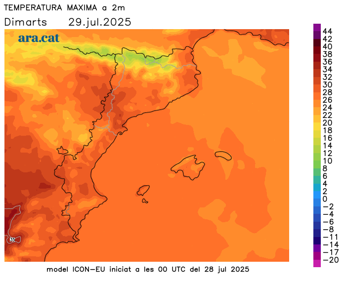
Temperatures will be similar or lower in mountain areas. They will only exceed 30°C again towards the west and inland from the Ebro. No warmer spells are in sight.
Wednesday will remain unstable. Throughout the day, scattered rain will continue in coastal and pre-coastal areas of Barcelona and in the northeast. They could be especially intense in the early morning. The northerly wind will decrease, but not completely disappear. Temperatures will fluctuate slightly, but there are no signs of warming.