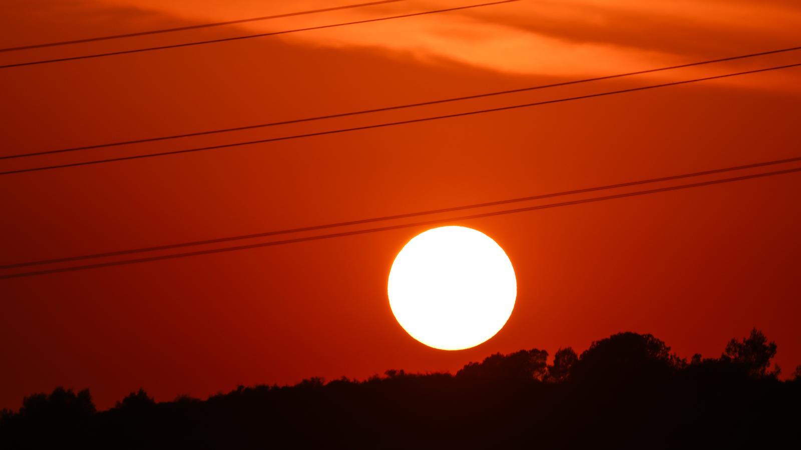
Sweltering weekend: the entire country on alert for the peak of the heat wave
Temperatures will peak on Sunday, with local temperatures reaching 44°C in the southern interior of the country.
BarcelonaThe new scorching peak of this long, second heat wave of the summer will reach its peak this weekend, especially tomorrow, Sunday, the day Meteocat has activated the red alert—the highest level—for intense heat in practically all the regions of Tarragona and the Alt Empordà, where temperatures will exceed 40°C. Occasionally, temperatures could reach 44°C in the interior of the Terres de l'Ebre. The rest of the country is also on yellow or orange alert for a generally stifling atmosphere.
The heat took a leap forward yesterday, especially inland. After two days without reaching 40°C, this figure was exceeded again in the southern interior of the country, locally with more than 42°C (you'll find all the data at the end of this report).

Civil Protection has activated the Procicat plan alert for this incident. And beware of the risk of forest fires, which will be especially high tomorrow, as dry, superheated winds will blow, lowering humidity in most regions. Sleeping will also be difficult at night in many regions, as tropical or torrid lows will be expected. The heat wave will last until Monday, although temperatures will begin to drop. And throughout the next week, the cooling off will be evident, definitively leaving behind one of the longest heat waves on record in our country.

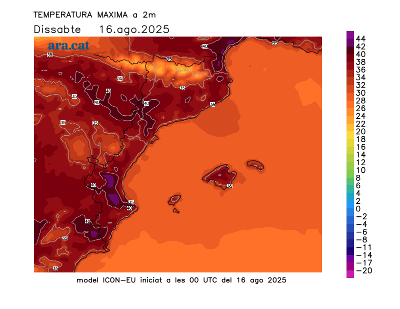
Saturday: intense heat throughout the country
Temperatures will rise further, both minimum and maximum. A sweltering day is expected, with tropical lows in many regions and some scorching temperatures—over 25°C—in some coastal areas, especially in the city of Barcelona, due to the urban heat island effect. Meteocat has activated several nighttime heat alerts for the coast and pre-coast throughout the weekend.
In the morning, the mercury will rise rapidly with a lot of heat, and most highs will range between 34°C and 39°C, slightly lower on the coast, but still very muggy. In Ponent and inland Ebro, temperatures will easily reach and exceed 40°C, locally reaching 42°C or 43°C. The 40°C mark could also be reached elsewhere inland or on the northeast pre-coastal, such as in Alt Empordà. Orange and yellow heat alerts have been issued for intense heat across virtually the entire country.
All with sunshine, calm, and the presence of suspended dust. Only a few harmless clouds will develop in the afternoon in mountainous areas in the north of the country, which will have no further consequences.
Sunday: peak of the heat wave
Tomorrow, temperatures will rise even further and reach their peak, especially on the southern coast and pre-coastline, due to the warm westerly wind. A warm wind will blow moderately and will be noticeable in many places, lowering the humidity. In Empordà and other areas in the north of the country, this wind will blow from the north wind. A combination of wind and low humidity will make the risk of fires especially high on the last day of the weekend.
Many highs of 35 to 40°C are expected, but in Ponent, inland Ebro, and Priorat, temperatures could again exceed 42°C or 43°C, and even reach or exceed 44°C on rare occasions. In the Tremp basin and in the Prepirin, temperatures could reach or exceed 40°C, as well as in the inland and pre-coastline of the Valencian Community. Meteocat extends intense heat alerts across the country, with a red warning for much of the Tarragona region and the Alt Empordà. A very sweltering day with generally sunny weather.
The end of the heat wave is already in sight
Monday will be the last day of the heat wave, but temperatures won't rise as much as they did on Monday. The drop in temperature will be more noticeable starting Tuesday, especially in the days following. Temperatures will begin to normalize after being about eight degrees above average these past few days. Therefore, the maps are confirming this cooling off, which will make us breathe much easier, both day and night.
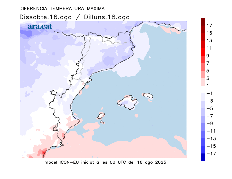
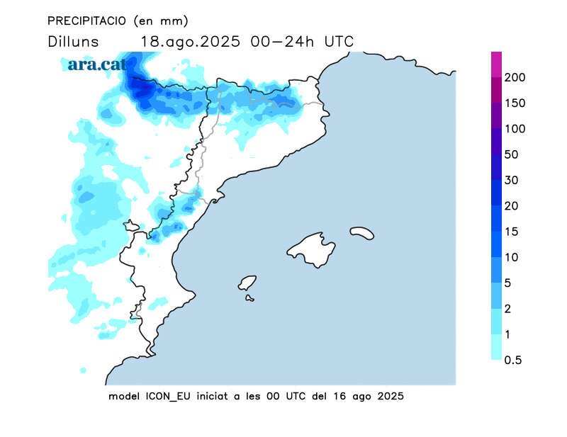
This change in weather will be associated with an influx of cold air from high altitude, which will bring showers and thunderstorms, especially in the Pyrenees, the Pre-Pyrenees, and central Catalonia.
Heat balance of the last 24 hours
This past Friday, temperatures rose further, especially in inland regions. After a pause of 40°C over the past two days, temperatures were reached again and exceeded in the southern interior of the country. The 42.6°C recorded in Vinebre (Ribera d'Ebre) stood out as the highest temperature of the day in the entire country. The atmosphere was stifling throughout the country, with many highs of 33°C to 38°C, outside the hottest areas. This Friday marked the 14th day this summer that a measuring point in the Meteocat Network of Automatic Meteorological Stations has exceeded 40°C. Seven in June, two in July, and five in the first half of August. This year, it equals the year with the most days of 40°C recorded at a Meteocat station so far. These are Friday's highest highs:
- 42.6 °C: Vinebre
- 41.6 °C: Aldover
- 41.1 °C: El Masroig
- 41.1 °C: Torroja del Priorat
- 41 °C: Ribarroja Reservoir
- 40.6 °C: Ascó
- 40.6 °C: Benissanet
- 40.5 °C: Tortosa (Roquetas)
- 40 °C: Cabacés
- 39.7 °C: Siurana reservoir
- 39.3 °C: Seròs
- 39.3 °C: Gandesa
