The sky is expected to continue in the coming hours: new showers and strong storms in several regions.
Warnings for some showers remain in effect today, with temperatures clearly dropping.

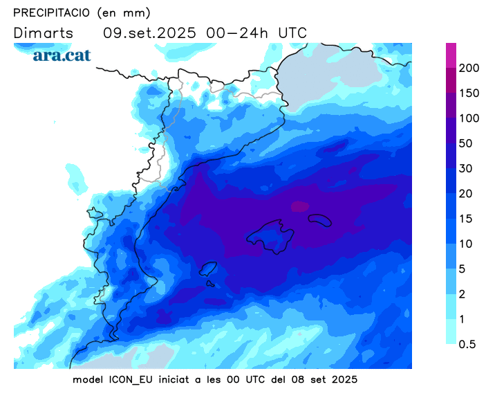
BarcelonaThe week has begun with a significant change in the weather. The arrival of an active cold front has reactivated the instability, with the reappearance of showers and severe thunderstorms in several regions. The most extensive rainfall fell tonight, and light to heavy rain fell almost everywhere, although the showers were very irregular. Parts of the northeast and the Ebro River have seen the most rainfall, with some accumulations well in excess of 50 l/m² locally (you'll find all the data at the end of this report). Also notable were the heavy downpours yesterday afternoon, accompanied by strong winds in some parts of the Valencian Community, where there were numerous incidents and fallen trees. Showers and thunderstorms will continue to appear in many areas over the coming hours.
Civil Protection maintains the Inuncat plan in alert phase, and Meteocat has warnings for heavy rain in many regions, especially during the morning between Barcelona and Tarragona. The downpours could leave locally more than 30 or 40 l/m² in just half an hour and cause rivers and streams to swell. Caution. Furthermore, in the south of the country, some records could reach 100 l/m² locally throughout the entire episode. All this with a clear drop in temperatures that will cause a marked cooling. The Diada long weekend will start off much quieter, but new changes could occur between Friday and Saturday.

Tuesday: The weather remains very unsettled.
During the morning, showers and heavy thunderstorms will continue between the regions of Tarragona and Barcelona, especially on the coast and pre-coastline. However, showers will continue to fall irregularly in more areas of the center and north of the country. In the afternoon, the sky will be changeable in Catalonia, and the precipitation will decrease significantly, although there will still be some scattered showers, more concentrated in the northern inland. Caution should be exercised between the Valencian Community and the Balearic Islands, as thunderstorms could be strong or very strong.
All this with temperatures that will clearly drop everywhere, both minimum and maximum. Minimums have already dropped, although in some cases they will be recorded later in the day. We wake up with cold temperatures in the high Pyrenees and generally cooler temperatures, and midday will be mild or not very warm overall. Many temperatures will range between 22 and 26°C, lower in mountain areas. The north wind will blow moderately in the Empordà region, especially in the north. There will also be some morning mistral winds on the Ebro.
Diada Bridge with a little bit of everything
On Wednesday, calm and sunshine will gain ground, but scattered showers will linger in the northeast and the Pyrenees. Thursday is Catalonia's National Day and a national holiday. It appears to be the most stable day of the week, with little risk of precipitation. However, the weather forecasts are predicting further increases in instability starting Friday, with the risk of some showers and thunderstorms. This is still an uncertain situation that we will need to confirm.
Temperatures will rise again thanks to more sunshine, but will remain around normal levels after this refreshment. A cool morning, even with chilly temperatures in mountain areas, will be mildly warm at midday. Only towards the West and inland areas will they approach 30°C this week.
Showers and severe thunderstorms in the balance.
The active cold front that arrived at the start of the week has caused a marked increase in instability. Between yesterday and today, the weather has been very unsettled, with little to no rain falling everywhere, albeit very irregularly. The most extensive rainfall occurred during the early hours of Tuesday morning, and there are areas where showers and thunderstorms have been intense and abundant. The areas most affected by the intense rain so far have been the Pyrenees and Pre-Pyrenees (especially the eastern one), points in the northeast, central Catalonia, the Ebro River, and between Camp de Tarragona and the southern coast and pre-coast of Barcelona. In these areas, records range from 50 to 100 l/m². This water has helped to somewhat recover the reservoirs in the inland basins after the summer decline, with a current level of 73%. There were also some notable downpours in the Valencian Community and especially in the Balearic Islands, with strong gusts causing damage and trees falling due to snapping. These are some of the most notable records from the entire episode in Catalonia:
- 115 l/m²: L'Aleixar
- 109 l/m²: Beget
- 95 l/m²: The Squirrel-Cantonigros
- 84 l/m²: Almadraba de Bages
- 82 l/m²: The Camp Forest
- 81 l/m²: Orís
- 76 l/m²: Berga
- 69 l/m²: Mas de Barberans
- 62 l/m²: Mieres
- 61 l/m²: El Port del Comte
- 61 l/m²: Sau Reservoir
- 60 l/m²: Sant Martí Sarroca
- 59 l/m²: Torredembarra
- 59 l/m²: Prats de Lluçanès
- 59 l/m²: L'Hospitalet de l'Infant
- 58 l/m²: Casserres
- 56 l/m²: Els Hostalets de Pierola
- 56 l/m²: Perafita
- 56 l/m²: El Vendrell
- 55 l/m²: Tamarit
- 54 l/m²: Montesquiu
- 53 l/m²: Artés
- 53 l/m²: Lladurs
- 52 l/m²: Fillers
- 52 l/m²: Villa-round
- 52 l/m²: Montserrat
- 52 l/m²: Miami Beach
- 50 l/m²: Queralt Sanctuary
- 50 l/m²: San Pablo de Segúries
- 45 l/m²: Riudecanyes
- 41 l/m²: Oliana
- 41 l/m²: Constantine
- 41 l/m²: La Quar
- 38 l/m²: La Tallada de Empordà
- 36 l/m²: La Ràpita-les Alfacs
- 36 l/m²: La Pobla de Segur
- 36 l/m²: Tempering
- 35 l/m²: Ulldecona
- 35 l/m²: Vinyols and els Arcs
- 34 l/m²: Darnius-Boadella Swamp
- 33 l/m²: Girona
- 32 l/m²: The Pont de Suert
- 31 l/m²: Molló
- 30 l/m²: Castellar de n'Hug
- 30 l/m²: Luck
- 30 l/m²: Vielha
- 29 l/m²: Organyà
- 28 l/m²: Banyoles
- 26 l/m²: Saint Peter the Fisherman
- 25 l/m²: Olot
- 23 l/m²: La Seu d'Urgell
