Atypical late summer weather and still some showers today
Many regions will not exceed 25ºC, and some more irregular storms will be repeated.

BarcelonaShowers and severe thunderstorms have swept across virtually the entire country in recent hours. After a busy Wednesday, this morning saw thunder and lightning in many areas, and repeated downpours. Accumulations ranged between 20 and 50 l/m² throughout the episode, most of which fell in a short period of time, but in some cases these figures were significantly exceeded, with hail, strong winds, and a large number of lightning strikes. Numerous incidents were recorded (you'll find all the data and images from this episode at the end of this report). However, in places like the Ebro and Priorat, there was virtually no rain. But this morning, above all, we noticed a significant cooling off.

Temperatures have dropped, and today will be a mild to cool day for the time of year, with a late-summer atmosphere. A few showers will linger at sea throughout the day, brushing coastal and pre-coastal areas. The main source of instability will be between the Balearic Islands and the Valencian Community.

Thursday: unusually cool and unstable
Throughout the day, there will be showers and some storms over the sea, which will graze coastal areas. Occasionally, they may reach the pre-coastal area. The sun will predominate in the west throughout the day. During the afternoon and evening, dark clouds will gather again in mountainous areas, bringing some showers and thunderstorms to parts of the Pyrenees, the Pre-Pyrenees, inland Girona, the pre-coastal area of Barcelona, and northern Central Catalonia. They will be more irregular and less severe, but some showers may still be locally intense. Meteocat maintains some alerts in this regard, both today and tomorrow.
The most severe instability will move to the Balearic Islands and the Valencian Community, especially in the southern regions of Valencia and Alicante. Showers will fall in these areas, while the most intense storms are expected between Ibiza and Cap de la Nau. Aemet has activated alerts for these areas. The mistral and north winds will blow strongly, especially during the morning in the Ebro and Empordà regions, with complicated maritime conditions.
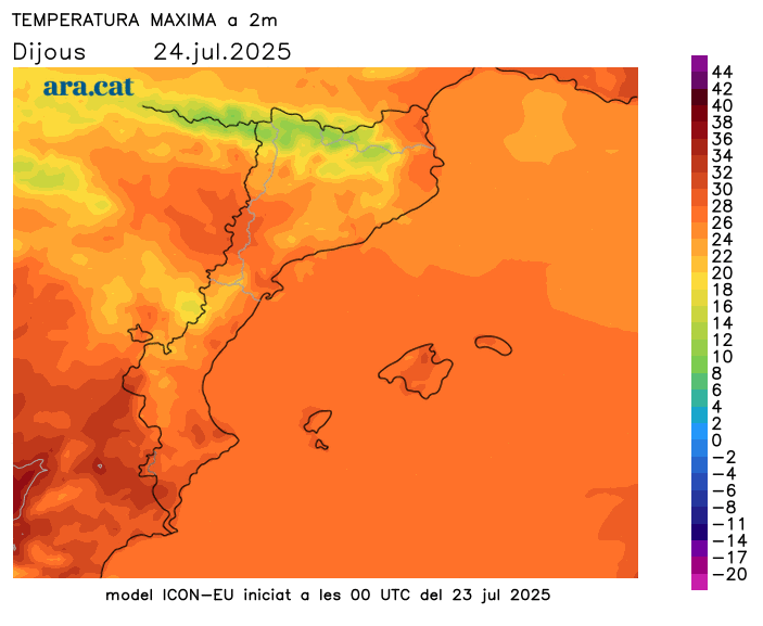
All this with a marked drop in temperatures. It will be a cool or rather warm day for the time of year, with values clearly below average. Many highs will range between 21°C and 27°C, lower in mountainous areas and higher in the West. The atmosphere is more reminiscent of late summer than the height of the summer heat.
No intense heat in sight
There will still be some showers remaining on Friday, but the weather will improve, and the weekend will be generally quite pleasant and enjoyable. Temperatures will gradually rise, but will remain moderately warm and very bearable. Nights will remain fairly cool and provide a good night's sleep, and no episodes of intense heat are in sight.
Balance of the strong storms
Showers and thunderstorms have affected many regions since Wednesday. Rain swept through many areas from west to east, especially during the night and early morning. This is now the case in Pallars Jussà. Many records range from 20 to 50 l/m² throughout the episode, but there are areas that far exceed these figures. The electrical activity has been significant, and since Wednesday, more than 10,200 cloud-to-ground lightning strikes have been recorded, according to data from the Meteocat Lightning Detection Network.
- 84 l/m²: Sant Salvador de Guardiola
- 82 l/m²: Casserres
- 81 l/m²: San Lorenzo Savall
- 80 l/m²: Roda de Ter
- 79 l/m²: La Garriga
- 78 l/m²: Fillers
- 73 l/m²: Cardona
- 70 l/m²: Castellterçol
- 66 l/m²: Montesquiu
- 66 l/m²: Caldes de Montbui
- 63 l/m²: Librona
- 60 l/m²: Olesa de Montserrat
- 60 l/m²: The Squirrel-Cantonigros
- 59 l/m²: The Quar
- 59 l/m²: Pujalt
- 57 l/m²: San Pedro de Ribes
- 56 l/m²: Olot
- 55 l/m²: Guixers-Valls
- 55 l/m²: Terrace
- 54 l/m²: Puig Sesolles
- 53 l/m²: Arts
- 53 l/m²: Perafita
- 52 l/m²: Berga
- 52 l/m²: Viladrau
- 52 l/m²: Pine
- 47 l/m²: Font-rubí
- 45 l/m²: English
- 42 l/m²: Sabadell
- 40 l/m²: Cervera
- 38 l/m²: Cabrils
- 35 l/m²: Barcelona (University Area)
- 34 l/m²: Barcelona (Raval)
- 32 l/m²: Cabanes

