Little change on a Thursday with thin clouds and a new surge in heat
The temperature will rise progressively in the coming days

BarcelonaWe remain in a state of meteorological monotony that will last for several days and will continue to be marked by the presence of some high clouds and intense heat (you'll find the highest temperatures reached so far at the end of this report). On Thursday, however, we'll have some new developments, with low clouds in some coastal areas and the growth of some dark clouds in the western Pyrenees.

Thursday: Temperatures rise again
The second half of the week will continue to be marked by intense heat, which will pick up again on Thursday and will once again make us sweat profusely everywhere. High cloud cover will persist, although some low cloud will also appear in parts of the southern coast and in the Empordà region. Southerly winds will also persist during the afternoon in the southern regions of Ponent. Furthermore, the dark clouds that grow during the afternoon in the Pyrenees could produce some more significant showers, but rainfall accumulations will be low overall.
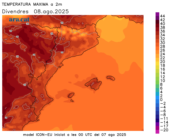
Friday: scattered afternoon showers in the Pyrenees
We'll be approaching the weekend with very stable and placid weather. The latest developments will include some low coastal clouds and the formation of afternoon storm clouds in the Pyrenees, bringing the risk of some more extensive showers than in previous days. Temperatures will generally remain fairly steady, although they will rise more strongly at mid- and high altitudes in the Pyrenees. The weather will be intense, with highs between 34°C and 38°C inland and 29°C to 32°C on the coast.

The heat will be intense in the next 15 days
The warm air mass from the south, which will send temperatures soaring, will accompany us throughout the first half of August, with highs that could once again reach or exceed 40°C or 41°C occasionally in the usual inland areas of the Ebro Valley, the West Bank, and the interior. Elsewhere, the heat will also be intense, with highs of 34°C to 37°C inland and 30°C to 33°C on the coast. It will be especially from Sunday onwards that the mercury will reach its highest values, and we could talk about the second official heat wave of the summer.
Nights will be heavier and more difficult to sleep in throughout the week, not only on the coast. In addition, the heatwave will be more intense along the coast and pre-coast. The situation will last for several days, and there is no rain or significant change in sight.
Heat Overview
Temperatures had already risen significantly on Monday, with many highs between 28°C and 32°C on the coast and above 36°C in Ponent and the south, but they rose further on Tuesday, when the highest values of the episode were recorded. On Wednesday, the mercury calmed down a bit, awaiting a further rise in temperature starting on Thursday. These are the most notable temperatures of this new episode of intense heat:
- Vinebre: 39.8°C
- Torroja del Priorat: 39.0 °C
- El Masroig: 38.6 °C
- Ribarroja Reservoir: 38.5 °C
- Benissanet: 38.2 °C
- Ascó: 37.7 °C
- Serazo: 37.6 °C
- Flails: 37.3 °C
- Aldover and Gimenells: 37.0 °C
