The heat wave peaks today, but it's almost over.
Red alert in several regions due to intense heat, but temperatures will clearly drop over the next week.


BarcelonaThe scorching peak of this second summer heat wave will reach its peak today, with Meteocat is issuing a maximum alert for intense heat in virtually all of the Tarragona and Barcelona coastal and pre-coastal regions, from Vallès Occidental and Barcelonés regions southward to the Alt Empordà region. The forecast is for temperatures to reach or exceed 40°C again in many pre-coastal and inland areas, and, as happened yesterday, for temperatures inland in the Terres de l'Ebre to occasionally reach 44°C. However, there is a lot of haze today due to the presence of suspended dust, but above all due to the arrival of smoke from the fires in the west of the Iberian Peninsula. A cloudier sky will likely be expected if it prevents temperatures from rising as high as yesterday, although technically, it is the most favorable day for recording the highest highs of the episode. Be that as it may, the heat will be extreme everywhere.
As for maximum temperatures, this past Saturday saw some record values, such as the 43.8ºC in Benissanet (Ribera d'Ebre) – the previous record was on August 23, 2023, when 42.9ºC was reached – or the 4.9ºC in Barcelona, which is the absolute record for a month of August in a series of 112 years. Also noteworthy were the 38.8ºC recorded in Malgrat de Mar (two and a half degrees higher than the absolute maximum ever recorded at this observatory). In some observatories in Barcelonès and Baix Llobregat, the highest values ever recorded were exceeded or equaled, and in regions such as Alt Penedès and Terres de l'Ebre they reached 43 ºC, just a few tenths of a second away from the records for absolute maximum temperatures in the month of August.
Yesterday's highest maximum temperatures were:
- 43.8 ºC: Benissanet
- 42.9 ºC: Vinebre
- 42.3 ºC: El Masroig (4 tenths below the absolute maximum of 42.7 ºC, on August 12, 2022)
- 42.3 ºC: Torroja del Priorat
At 1 p.m. today, Sunday, we recorded a high of 39.4°C in Miami Platja (Mont-roig del Camp). This figure is almost 1 degree higher than the absolute maximum recorded in August (38.5°C, on August 5, 2018).
You'll find more information on records at the end of this article. Civil Protection maintains the Procicat alert for this event. Furthermore, the risk of forest fires will be extreme today, as dry, superheated winds will blow, lowering humidity in most regions.

Sunday: last day of the heat wave
The early hours of the morning were particularly difficult to sleep on along the coast, with lows ranging between 27°C and 29°C. The night was scorching hot in some coastal areas, especially around Cap de Creus, where the superheated north wind blew, and temperatures did not drop below 30°C for most of the night. In Roses, for example, the low did not drop below 30.7°C.

Today, temperatures will rise further and reach their peak, especially on the southern coast and pre-coast, due to the westerly wind. It will be a moderately heated wind that will be noticeable in many places, as the humidity will drop. In the Empordà region and other areas in the north of the country, this wind will blow from the north wind.
Many highs of 35°C to 40°C are expected, but in the West, inland Ebro, and Priorat, temperatures could again exceed 42°C or 43°C, and even reach or exceed 44°C on rare occasions. In the Conca de Tremp region, in the western Pre-Pyrenees, and in the pre-coastal region, temperatures could exceed 40°C, as well as inland and pre-coastal regions of the Valencian Community. Meteocat extends intense heat alerts across the country, with a red warning for much of the Tarragona region, most of the coast and pre-coastal region of Barcelona, in the Alt Empordà region, and in Pla de l'Estany. A very sweltering day that will be generally sunny, with haze due to suspended dust and smoke from the fires in the west of the Iberian Peninsula, which we will see if they slow the rise of the mercury more than expected.

Next week: more bearable and cooler heat in the Pyrenees
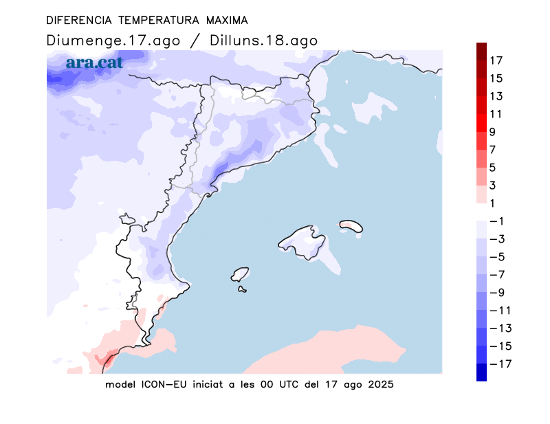
For this Monday, the models show the departure of the warm African air pocket, and temperatures will already drop, although it will still be very hot. This will be the last day of the heat wave, with the expected drop in temperature becoming more noticeable starting Tuesday, especially in the following days. Temperatures will begin to normalize after being about eight degrees above average these past few days. Therefore, the maps are confirming this cooling off, which will make us breathe much easier, both day and night. In the Pyrenees, we should grab a blanket at night, because lows around 9°C are expected in the valleys.
This change in weather will be associated with an influx of cold air from high altitude, bringing showers and thunderstorms, especially in the Pyrenees, the Pre-Pyrenees, and central Catalonia. The first thunderstorms will appear on Monday and by Tuesday, they will spread to more regions, possibly reaching the coastline. Hail or hailstorms are not ruled out.

Meteocat has issued a warning for heavy rain and violent phenomena.

Heat wave balance
This Friday, temperatures rose further, especially in the inland regions. After a break from 40°C over the past two days, temperatures were reached again and exceeded in the southern interior of the country. The 42.6°C recorded in Vinebre (Ribera d'Ebre) stood out as the highest temperature of the day in the entire country. The atmosphere was stifling throughout the country, with many highs of 33°C to 38°C outside the hottest areas. This Saturday saw a repeat of the extreme heat, marking the 15th day this summer on which the Meteocat Network of Automatic Meteorological Stations has reached or exceeded 40°C. Seven in June, two in July, and six in the first half of August. This is the year with the most days above 40°C in the history of records in Catalonia. Numerous heat records were broken on Saturday.
Saturday's highest temperatures:
- 43.8 °C: Benissanet (the previous historical value was 42.9 °C, on August 23, 2023)
- 42.9 ºC: Vinebre
- 42.3 ºC: El Masroig (4 tenths below the absolute maximum of 42.7 ºC on August 12, 2022)
- 42.3 ºC: Torroja del Priorat
- 41.7 ºC: Ribarroja reservoir
- 41.1 ºC: San Sadurní de Anoia
- 40.4 ºC: Espolla
- 39.7 ºC: El Prat de Llobregat (equal to the record of 39.7 ºC on August 23, 2023)
- 39.4 ºC: Lleida - La Fenosa
- 38.9 ºC: Barcelona - Fabra Observatory, manual station (surpasses the record of 38.5 ºC of August 23, 2023).
- 38.8 ºC: Malgrat de Mar (exceeds the record of 36.3 ºC of August 5, 2018)
- 37.4 ºC: the Rascler - Garraf Natural Park (exceeds the record of 36.7 ºC of August 23, 2023)
