Afternoon showers locally heavy in some places to start August
Temperatures will remain without extremes, but intense heat will return next week.

BarcelonaJuly has ended very calmly, especially with an increase in heat and muggy conditions. Yesterday in the West and inland Ebro, temperatures reached 32°C to 35°C. A truly summery atmosphere, but far from extreme. And August begins today with a slight increase in instability that will bring a return of showers and afternoon thunderstorms in some regions, which are locally intense. Temperatures will drop slightly over the weekend and remain moderate, but next week they will rise sharply, and we will see the return of truly sweltering heat.

Friday: afternoon thunderstorms
The first day of August begins with a calm and fairly sunny morning. There are only a few cloudy patches in parts of the central and pre-coastal areas and areas of the northeast. Minimum temperatures have risen and have been tropical along the coast, with cool to mild temperatures at night in the rest of the country. From midday and into the afternoon, the clouds will grow steadily in mountain areas, bringing irregular showers and thunderstorms. They will primarily affect parts of the interior and the northeastern pre-coastal area, the Pyrenees and the eastern Pre-Pyrenees, and the interior of the Valencian Country. They could be heavy, so Meteocat has issued warnings for heavy rain in several regions.
Showers are also expected to reach the Barcelona coast and pre-coast, as well as the southern Costa Brava and the Valencian coastline. All this with moderate mistral and tramontana winds during the morning in the northern Alt Empordà and the Ebro, and fairly similar temperatures. It will be hot and muggy without extremes in the middle of the day. Many highs of 25°C to 30°C, again higher in the west and inland south.
Last days of heat at bay
Temperatures will even drop slightly on Saturday, with moderate warmth and nights that will continue to provide good sleep in most regions over the weekend. Tropical lows will only be repeated near the sea and perhaps in areas of the south. But next week, temperatures will rise sharply, especially starting Tuesday. We will regain the intense, scorching heat, and it looks like we'll have several days with above-average temperatures.
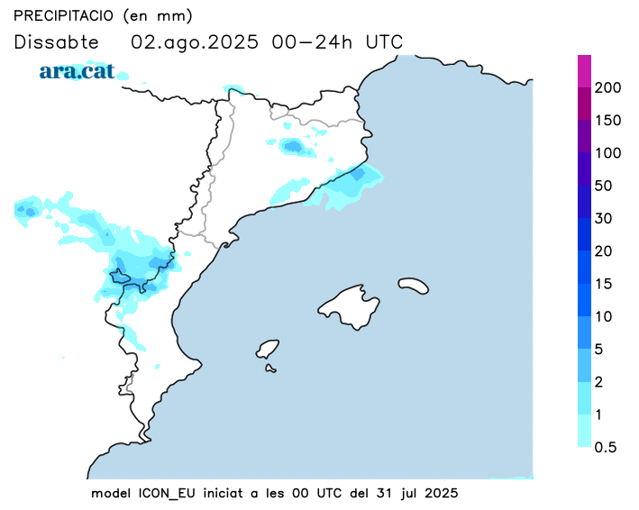
All this with new afternoon showers on Saturday in the northeast, the Pyrenees, and the Valencian Community, as well as some in the morning on the coast and in the central pre-coast. On Sunday, instability will ease, and over the weekend, there will be a temporary strengthening of the Tramuntana wind in the Empordà region. Next week will be placid and sunny.