To revive the country, devastated by the civil war, the Franco regime promoted the construction of numerous reservoirs. One of the regime's most emblematic is the Canelles dam, created to generate electricity and meet irrigation and drinking water supply needs. The Canelles power plant and its dam were built by the ENHER company in just six years, from 1953 to 1959. The dam was designed by engineer Eduardo Torroja. The project employed thousands of workers. They lived with their families in a temporary camp—the so-called "Canelles settlement"—much larger than any other village in the surrounding area. When this settlement closed in the early 1980s, many remained in the area to live there permanently.
Freshwater heritage
Chickpea paste prevents leaks
The capture of Canelles
08/09/2025

3 min
Estopanyà (in Spanish, everything is always longer: Estopiñán del Castillo) is a pretty village in the Franja de Poniente region, home to just under a hundred people. Walking around, you feel like you speak more Catalan than in Barcelona. It's quite busy because it's one of the starting points for a visit that has become very popular: the "Great Wall of Finestres," located next to the Canelles reservoir and the abandoned village of Finestres. This village was abandoned in the mid-1950s. The construction of the reservoir flooded its most fertile lands and cut off the river links it had with its neighboring towns. "When people ask me how to get to the Great Wall of China, I tell them it's 13,000 kilometers," Benjamín Vallmanya from Estopanyà tells me. "Here we've always called it 'The Rocks of the Town' or 'The Teeth of Ventanas'."
Benjamín is the manager of the Canelles Dam Energy and Geology Interpretation Center, an interesting exhibition on the history of the dam and power plant construction. I'm visiting it today. We have to travel a few kilometers from Estopanyà to reach the foot of the dam, which is located between the municipalities of Estopanyà (Ribagorça) and Os de Balaguer (Noguera). We drive through them in his small car, little by little, along a completely secondary road. We don't encounter a single vehicle along the entire route. We enter the most uninhabited and unspoiled Montsec region, passing near one of the most popular via ferratas in the country, Lo Pas de la Savina, with its very high walls. One of the routes bears his name (not his surname). Yes, via Benjamín.
"The area of the Canelles Strait, where the dam is located, is very karst," Benjamín tells me, sitting at the wheel of the car. "When the reservoir began to be filled, significant water leaks were detected, so it wasn't completely filled until 35 years later, when they were resolved. A very complex operation was required in which bentonite—very fine clay—was injected into the concrete, along with other elements such as carbona and charcoal (it adheres very well to the stone), and chickpea paste (it swells when wet)," he explains.
One of the highlights of the interpretation center's exhibition are the photographs of the dam's construction. There are beautiful black-and-white images of the village of Blancafort, from 1955. Shortly afterward, it would be flooded by the Canelles reservoir (another village, Tragó de Noguera, would be flooded by the Sant Anna reservoir, located slightly lower downstream than Canelles).
One of Leo Messi's great-grandmothers lived in Blancafort, and she emigrated long before the village was submerged. Many of Montsec's inhabitants left at the beginning of the 20th century. This was a poor place, with scarce resources: cereals were grown on small plots, along with nuts, olives, and honey (which has developed into "honey cooking," very popular today).
Next to the exhibition huts, there are unused pieces from the power plant, unmarked. "Someday we'll make an open-air museum of all this," says Benjamín. There's still work to be done.
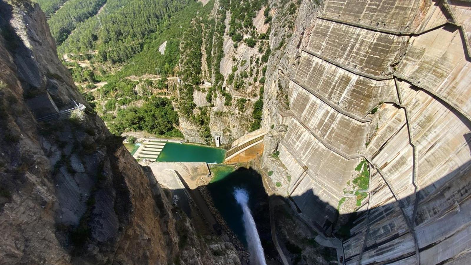
We then walked to the dam. As we got closer, it became even more impressive. The wall was extremely high, impressive: 152 meters high. Of course, it was a containment dam for an immense reservoir, the largest in the Noguera Ribagorçana basin and the second largest in the Ebro basin, after Mequinenza. "This dam is still studied by many universities today due to the complexity of its construction," says Benjamín. When we got close, we saw the water gushing out of a pipe at high pressure, creating a beautiful rainbow. We got closer and were refreshed by tiny splashes of water. It was an ideal experience for a stiflingly hot day like today. I'd have stayed a while, but we still had one more attraction to see: the black cave of Tragó (other caves there were covered with concrete to stop leaks). The black cave is accessed from the side of the dam's highest point. Well equipped with the helmet Benjamin gave me, I tour a section of the cave. We're greeted by a group of bats flying quite fast. "Thirteen species of bats have been detected here," Benjamin tells me. "The bat is a farmer's best friend," he emphasizes. "Every day they eat a lot of insects: one and a half times their body weight." "That means they "go to the bathroom" quite often," I say. At one point, as I look down, I see a toad. Of course, there are some pools of water, its habitat.
There's a narrow passage, but the path is easy, almost horizontal. "Human remains were found in this cave, dating from between 12,000 and 14,000 BC, as well as arrowheads and axes," explains Benjamin.
"These stalactites are completely destroyed!" I exclaim. "Yes, they're from years ago, when there was no concern about respecting heritage and many people broke them up and sold them. Some ended up as ornamental elements in cemeteries," says Benjamin. What a shame!
One of the most emblematic hydraulic works of Franco's regime

